1900s (20th Century) Maps of Saint Lucie County, Florida
Explore 34 historic maps of Saint Lucie County from the 1900s (20th Century). These maps offer a rare glimpse into what life looked like during the 1900s — showing old roads, neighborhoods, homes, and landmarks that have changed or disappeared over time.
Whether you're researching your family's past, planning a metal detecting trip, or studying how Saint Lucie County's landscape evolved across the 1900s, these high-resolution maps are a powerful tool for exploring the history of this region.
- Focus on a specific era: All maps on this page are from the 1900s, giving you a focused view of this time period.
- See what’s changed: Compare century-old streets, trails, and buildings to today's modern landscape using overlays and satellite layers.
- Research with precision: Use these maps for genealogy, historical research, land use analysis, or educational projects.
- View, download, or print: Maps are fully viewable online in high resolution, and can be downloaded or printed for your own records.
Start exploring Saint Lucie County's history through authentic maps from the 1900s. This is your window into the past.
Saint Lucie County, FL maps
(34)- 1948 Map of Palm City, 1956 Print
 1948 Palm City1956 Print · USGSThe St. Lucie River waterfront comes alive in this post-war survey, showing the rail and river networks of the Florida coast. Researchers can trace the development of Stuart and Palm City alongside landmarks like the Roosevelt Bridge and Union Ch.5 unique versions available
 - 1948 Map of Ankona, 1956 Print
 1948 Ankona1956 Print · USGSThe St. Lucie riverfront and coastal lagoons appear here in the late 1940s, just as the regional drainage and transport networks were maturing. Researchers can trace early infrastructure through the Florida East Coast rail line and communities like White City and Ankona.4 unique versions available
 - 1948 Map of Eden, 1965 Print
 1948 Eden1965 Print · USGSThe Florida coast near the St. Lucie and Martin County line appears here just after the war, defined by the narrow barrier of Hutchinson Island. You can trace the path of the Florida East Coast railway through Eden and find the early footprint of Jensen Beach.3 unique versions available
 - 1948 Map of Indrio, 1968 Print
 1948 Indrio1968 Print · USGSThe Florida coast near the Indian River and St. Lucie line appears here in the late 1940s, just as the postwar era began to reach these shores. Genealogists and local historians can trace the Florida East Coast railroad through Viking and Indrio, or locate the old Cem near the riverfront.4 unique versions available
 - 1949 Map of Fort Pierce, 1960 Print
 1949 Fort Pierce1960 Print · USGSFort Pierce and the Atlantic coast are captured here in the late nineteen-forties as the region's citrus and maritime identity took shape. Researchers can trace the development of White City, locate Gem Church, and study the early layout of Hutchinson Island.6 unique versions available
 - 1949 Map of Oslo, 1964 Print
 1949 Oslo1964 Print · USGSCoastal Florida in the late forties shows a landscape of citrus groves and early development along the Florida East Coast railway. Researchers can trace the layout of McKee Jungle Gardens and the old settlement sites of Oslo and Indrio.3 unique versions available
 - 1949 Map of Fort Pierce NW, 1983 Print
 1949 Fort Pierce NW1983 Print · USGSSt. Lucie County witnessed significant infrastructural growth during the mid-century as citrus groves and aviation fields expanded. Trace the development of Floridas Turnpike and find local landmarks like Tenmile Creek and the Trailer Park.
 - 1950 Map of Ankona
 1950 Ankona1950 Print · USGSThe Florida coast near White City is shown here just after the war, when rail and river dominated the landscape. Genealogists and historians can trace the early layout of Ankona and Walton along the Indian River and the Florida East Coast railway.
 - 1950 Map of Fort Pierce
 1950 Fort Pierce1950 Print · USGSFort Pierce and the surrounding St. Lucie County coast come alive in this mid-century survey. Genealogists and local historians can trace the development of White City, locate the White City Cem, and explore the rail corridor of the Florida East Coast.
 - 1950 Map of Palm City
 1950 Palm City1950 Print · USGSMid-century coastal Florida comes alive in this survey of the river forks and early development near the Atlantic coast. Genealogists and local historians can trace the foundations of Stuart and Palm City, locating landmarks like Union Ch and the Fern Hill Cem.
 - 1950 Map of Fort Pierce NW
 1950 Fort Pierce NW1950 Print · USGSSt. Lucie County was a landscape of citrus groves and emerging aviation hubs just after the war. Researchers can trace early infrastructure along Kings Highway, the St Lucie County Airport, and the winding Tenmile Creek.2 unique versions available
 - 1950 Map of Oslo
 1950 Oslo1950 Print · USGSCoastal Florida in the early postwar years reveals a landscape of expanding citrus groves and drainage projects near the Indian River Co line. You can trace the Florida East Coast rail corridor and find early roadside landmarks like McKee Jungle Gardens and the settlement of Oslo.2 unique versions available
 - 1950 Map of Indrio
 1950 Indrio1950 Print · USGSThe Florida Atlantic coast and Indian River lagoon are shown here in the late 1940s as citrus groves and coastal hamlets began to expand. You can trace early transport routes and the small settlement of Viking or explore the marshy banks of Prang Island Cr.
 - 1950 Map of Eden
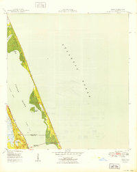 1950 Eden1950 Print · USGSThe Florida coast near the Saint Lucie and Martin County line is captured here just after the war, showing the narrow reach of Hutchinson Island. You can trace the Florida East Coast rail line as it passes through Eden and across the Jensen Beach Bridge.
 - 1953 Map of Okeechobee 1 SE, 1954 Print
 1953 Okeechobee 1 SE1954 Print · USGSSt. Lucie County in the early fifties showcases a landscape being reshaped by massive drainage and reclamation projects. Researchers can trace the engineering of the Allapattah Flats through its system of Levees, Rim Ditches, and the Florida East Coast rail line.3 unique versions available
 - 1953 Map of Okeechobee 4 NE, 1954 Print
 1953 Okeechobee 4 NE1954 Print · USGSIn the early 1950s, the Florida interior along the St. Lucie and Martin County line remained a landscape of wetlands and isolated hammocks. Researchers can trace the Florida East Coast rail line and locate old sites like Bluefield and Myer Hammock.4 unique versions available
 - 1953 Map of Fellsmere 4 SE, 1954 Print
 1953 Fellsmere 4 SE1954 Print · USGSThe Florida interior near the Indian River and St. Lucie line appears here in the early fifties as a managed wetland frontier. Researchers can trace the extensive hydrological works of the era, including a major Levee, numerous Spoil Banks, and several Flowing Wells bordering Johns Marsh.5 unique versions available
 - 1953 Map of Fellsmere 4 SW, 1954 Print
 1953 Fellsmere 4 SW1954 Print · USGSFlorida's inland wetlands meet mid-century engineering along the tri-county line of Indian River, Okeechobee, and St Lucie. Researchers can trace the massive drainage efforts through early Levee systems and isolated landmarks like Sick Island and Gum Slough.4 unique versions available
 - 1953 Map of Okeechobee 4 NW, 1954 Print
 1953 Okeechobee 4 NW1954 Print · USGSThe northeastern shore of Lake Okeechobee is captured here in the early 1950s, showing a landscape defined by drainage projects and competing rail lines. Researchers can trace the paths of the Seaboard Air Line, find the settlement at Myrtle, and locate numerous Flowing Wells across the marsh.4 unique versions available
 - 1953 Map of Okeechobee 1 SW, 1954 Print
 1953 Okeechobee 1 SW1954 Print · USGSFlorida's interior scrub and wetlands are documented here in the early fifties before major modern drainage projects. Researchers can trace the natural watercourse of Cypress Creek and locate family-named landmarks like Dark Hammock and Jones Hammock.4 unique versions available
 - 1953 Map of Indian Town NW, 1955 Print
 1953 Indian Town NW1955 Print · USGSFlorida's interior wetlands meet early infrastructure in the early 1950s along the boundary of Martin and St. Lucie counties. Researchers can trace the drainage of the Allapattah Flats through an early Canal, the Green Ridge Slough, and several Levee systems.6 unique versions available
 - 1953 Map of Okeechobee 1 NE, 1955 Print
 1953 Okeechobee 1 NE1955 Print · USGSThe northern reaches of St. Lucie County appear in the early fifties as a landscape undergoing major transformation through drainage and water control. Researchers can trace the early engineering of the St Johns Marsh via the Rim Ditch and various Levee systems.3 unique versions available
 - 1953 Map of Okeechobee 1 NW, 1955 Print
 1953 Okeechobee 1 NW1955 Print · USGSThe Florida interior along the Okeechobee Co St Lucie Co border was undergoing significant drainage transformation in the early fifties. Researchers can trace the early infrastructure of the region through dozens of a Flowing Well, early Levee systems, and the natural courses of Gomez Creek.3 unique versions available
 - 1953 Map of Fort Pierce SW, 1955 Print
 1953 Fort Pierce SW1955 Print · USGSCoastal Florida's interior was undergoing a massive hydrological transformation in the early 1950s. Trace the development of reclaimed lands along the Florida East Coast railway and study the complex system of the Header Canal and Flowing Wells.4 unique versions available
 - 1956 Map of Fort Pierce, 1965 Print
 1956 Fort Pierce1965 Print · USGSCentral and coastal Florida appear here during a period of rapid post-war growth and industrial expansion. Researchers can trace the mid-century rail-to-highway transition along the Sunshine State Parkway or locate old settlements like Ankona, Walton, and Indrio.4 unique versions available
Showing maps 1-25 of 34
Top cities of Saint Lucie County
- Port Saint Lucie historical maps
- Fort Pierce historical maps
- Lakewood Park historical maps
- River Park historical maps
- White City historical maps
- Saint Lucie Village historical maps
Frequently asked questions
- What are the different types of historical maps available for Saint Lucie County?
- What is the oldest map of Saint Lucie County?
- Where can I purchase historical maps of Saint Lucie County for my home or office?
- Where can I download high-res historical maps of Saint Lucie County?
- Are there historical topographic maps available for Saint Lucie County?
- Is there historical aerial imagery available for Saint Lucie County?
- Where are historical maps of Saint Lucie County sourced from?