1970s Maps of Parkerville, Florida
Explore 2 historic maps of Parkerville from the 1970s. These maps offer a rare glimpse into what life looked like during the 1970s — showing old roads, neighborhoods, homes, and landmarks that have changed or disappeared over time.
Whether you're researching your family's past, planning a metal detecting trip, or studying how Parkerville's landscape evolved across the 1970s, these high-resolution maps are a powerful tool for exploring the history of this region.
- Focus on a specific era: All maps on this page are from the 1970s, giving you a focused view of this time period.
- See what’s changed: Compare century-old streets, trails, and buildings to today's modern landscape using overlays and satellite layers.
- Research with precision: Use these maps for genealogy, historical research, land use analysis, or educational projects.
- View, download, or print: Maps are fully viewable online in high resolution, and can be downloaded or printed for your own records.
Start exploring Parkerville's history through authentic maps from the 1970s. This is your window into the past.
Parkerville, FL maps
(2)- 1970 Map of Harold SE, 1973 Print
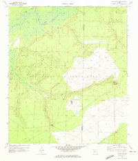 1970 Harold SE1973 Print · USGSThe Yellow River corridor in the Florida Panhandle is captured here during the early 1970s, showing a mix of rural river life and military expansion. Genealogists and historians can locate Parkerville, the Flowers Field Cem, and the aircraft facilities at Aux Field No 7.2 unique versions available
 - 1978 Map of Crestview, 1982 Print
 1978 Crestview1982 Print · USGSThe Florida Panhandle and southern Alabama borderlands appear here in the late seventies as the military and timber industries shaped the landscape. Genealogists can trace family roots through small settlements like Cannon Town or Svea, and locate old sites like Aux Field No 4 (Abandoned).2 unique versions available
End of results
Showing maps 1-2 of 2
Top cities near Parkerville
- Navarre historical maps
- Crestview historical maps
- Fort Walton Beach historical maps
- Milton historical maps
- Mary Esther historical maps
Frequently asked questions
- What are the different types of historical maps available for Parkerville?
- What is the oldest map of Parkerville?
- Where can I purchase historical maps of Parkerville for my home or office?
- Where can I download high-res historical maps of Parkerville?
- Are there historical topographic maps available for Parkerville?
- Is there historical aerial imagery available for Parkerville?
- Where are historical maps of Parkerville sourced from?