1970s Maps of Village of Bridgeport at Lake Miona, The Villages
Explore 2 historic maps of Village of Bridgeport at Lake Miona from the 1970s. These maps offer a rare glimpse into what life looked like during the 1970s — showing old roads, neighborhoods, homes, and landmarks that have changed or disappeared over time.
Whether you're researching your family's past, planning a metal detecting trip, or studying how Village of Bridgeport at Lake Miona's landscape evolved across the 1970s, these high-resolution maps are a powerful tool for exploring the history of this region.
- Focus on a specific era: All maps on this page are from the 1970s, giving you a focused view of this time period.
- See what’s changed: Compare century-old streets, trails, and buildings to today's modern landscape using overlays and satellite layers.
- Research with precision: Use these maps for genealogy, historical research, land use analysis, or educational projects.
- View, download, or print: Maps are fully viewable online in high resolution, and can be downloaded or printed for your own records.
Start exploring Village of Bridgeport at Lake Miona's history through authentic maps from the 1970s. This is your window into the past.
Village of Bridgeport at Lake Miona, The Villages maps
(2)- 1979 Map of Inverness, 1980 Print
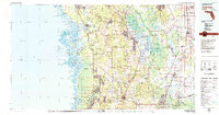 1979 Inverness1980 Print · USGSThe West Central Florida coastline and lake regions are captured here in the late seventies, showing the transition from Gulf marshes to the interior wetlands. Genealogists and researchers can locate family sites near Inverness or trace the early rail corridors of the Seaboard Coast Line through Wildwood and Okahumpka.2 unique versions available
 - 1979 Map of Orlando, 1980 Print
 1979 Orlando1980 Print · USGSCentral Florida's lake country and growing urban corridors are captured here just before the decade's end. Genealogists and historians can trace the transition from citrus rail towns like Winter Garden to the suburban expansion along I-4 and Florida's Turnpike.3 unique versions available
End of results
Showing maps 1-2 of 2
Frequently asked questions
- What are the different types of historical maps available for Village of Bridgeport at Lake Miona?
- What is the oldest map of Village of Bridgeport at Lake Miona?
- Where can I purchase historical maps of Village of Bridgeport at Lake Miona for my home or office?
- Where can I download high-res historical maps of Village of Bridgeport at Lake Miona?
- Are there historical topographic maps available for Village of Bridgeport at Lake Miona?
- Is there historical aerial imagery available for Village of Bridgeport at Lake Miona?
- Where are historical maps of Village of Bridgeport at Lake Miona sourced from?