Old Maps of New Smyrna Beach, Volusia County for Metal Detecting
Plan your next treasure hunt with 50 historic maps of New Smyrna Beach. Find old homesites, ghost towns, trails, and gathering spots that may be lost to time — perfect for identifying promising metal detecting locations.
- Locate forgotten sites: Uncover places like long-lost settlements, abandoned rail lines, or gathering spots.
- Plan better hunts: Use map overlays combined with LiDAR or satellite views to narrow in on historically rich areas.
- Made for detectorists: Thousands of hobbyists use these maps to discover relics, coins, and hidden history.
Use these historic maps to boost your research and find new opportunities beneath the surface of New Smyrna Beach.
New Smyrna Beach, Volusia County maps
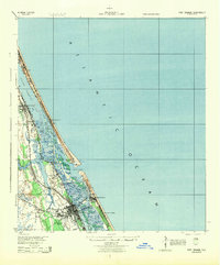
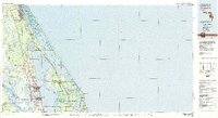
(50)- 1937 Map of Port Orange
 1937 Port Orange1937 Print · USGSThe Volusia County coastline in the late thirties shows a burgeoning network of seaside colonies and rail-connected towns. Genealogists and historians can trace old homesteads and landmarks like the Old Franciscan Mission, Isleboro, and the East Coast Railway.
 - 1943 Map of Port Orange, 1959 Print
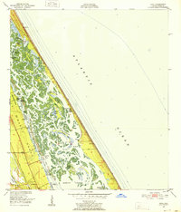
 1943 Port Orange1959 Print · USGSThe Florida Atlantic coast during the mid-1940s reveals a landscape of tidal rivers and growing seaside resorts. Researchers can trace the early layout of Port Orange and New Smyrna, locate the Old Franciscan Mission, and see the rail network of the Florida East Coast.
 - 1944 Map of Port Orange
 1944 Port Orange1944 Print · USGSThe Volusia County coastline during the Second World War reveals a landscape of tidal marshes and emerging seaside towns. Genealogists and historians can trace the early footprints of Port Orange, Allandale, and the Old Franciscan Mission along the Halifax River.
 - 1950 Map of Ariel, 1952 Print
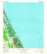
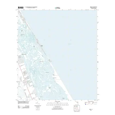
 1950 Ariel1952 Print · USGSThe Volusia County coast during the early fifties reveals a landscape of massive land grants and intricate barrier islands. Genealogists and local historians can trace the bounds of the Joseph Wales Grant or locate old sites like Eldora and Turtle Mound.4 unique versions available
 - 1950 Map of Edgewater, 1952 Print
 1950 Edgewater1952 Print · USGSThe Volusia County coastline in the early fifties remains a patchwork of historic Spanish land grants and emerging rail towns. Genealogists and historians can trace family-named landmarks like the Ambrose Hull Grant alongside settlements at Edgewater and Hucomer.5 unique versions available
 - 1952 Map of Samsula, 1956 Print
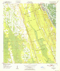
 1952 Samsula1956 Print · USGSCoastal Volusia County is shown in the early fifties as the rural community of Samsula began to expand around its agricultural roots. Researchers can trace the legacy of early aviation at Spruce Creek Airport and follow the path of the Old Railroad Grade.6 unique versions available
 - 1954 Map of Daytona Beach, 1974 Print
 1954 Daytona Beach1974 Print · USGSNortheast Florida is captured in the mid-1950s, showing the transition from river-based commerce to coastal tourism. Researchers can trace the Florida East Coast rail lines and find historic sites like Castillo de San Marcos Nat Mon and Palatka.
 - 1955 Map of Orlando, 1969 Print
 1955 Orlando1969 Print · USGSCentral Florida was entering the space age in the mid-fifties, balancing its citrus heritage with new military and aerospace frontiers. You can trace early developments at Kennedy Space Center or locate interior settlements like Eatonville and Pine Castle.3 unique versions available
 - 1956 Map of New Smyrna Beach, 1960 Print
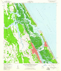 1956 New Smyrna Beach1960 Print · USGSThe Volusia County coastline in the mid-fifties reveals a period of significant growth along the Indian River and Halifax River. Researchers can trace the development of New Smyrna Beach, the legacy of Chisolm High Sch, and the layout of the Florida East Coast Railroad.6 unique versions available
 - 1956 Map of Port Orange, 1964 Print
 1956 Port Orange1964 Print · USGSThe Volusia County coastline comes alive in the mid-fifties, showing the growth of beach communities and the vital Florida East Coast rail line. Genealogists and historians can locate Woodland Cem, Chisholm High Sch, and maritime landmarks near Ponce de Leon Inlet.
 - 1957 Map of Orlando
 1957 Orlando1957 Print · USGSCovers New Smyrna Beach, including Orlando, Palm Bay, and other nearby areas
 - 1958 Map of Orlando
 1958 Orlando1958 Print · USGSCentral Florida was a landscape of citrus, rail, and emerging aerospace technology during the late fifties. Researchers can trace the early footprints of Cape Canaveral and Patrick Air Force Base or locate inland citrus and rail hubs like Sanford and Lakeland.
 - 1958 Map of Daytona Beach
 1958 Daytona Beach1958 Print · USGSThe Florida coast and St. Johns River valley are captured in the late 1950s, showing a landscape defined by citrus-belt rail towns and Atlantic shorelines. Genealogists can trace family roots through riverside settlements like Palatka and Welaka or coastal hubs like Daytona Beach.2 unique versions available
 - 1962 Map of Orlando
 1962 Orlando1962 Print · USGSCentral Florida was transformed by aerospace and citrus at the start of the sixties. Genealogists and historians can trace old community footprints from Eau Gallie to Leesburg, alongside landmarks like McCoy AFB and the winding Econlockhatchee River.
 - 1964 Map of Daytona Beach
 1964 Daytona Beach1964 Print · USGSCoastal Florida in the mid-1960s shows a fascinating balance between burgeoning beach tourism and the deep interior wilderness of the Ocala National Forest. Researchers can trace the path of the Florida East Coast railway through historic settlements like St. Augustine, Marineland, and Palatka.
 - 1966 Map of Lake Ashby, 1968 Print
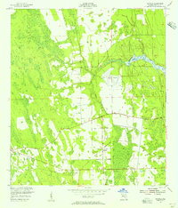
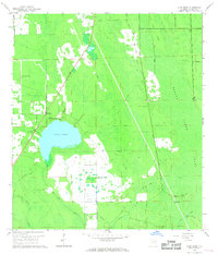 1966 Lake Ashby1968 Print · USGSVolusia County's interior wetlands and settlements are captured here in the mid-1960s as drainage projects shaped the landscape. Genealogists and historians can locate Alamana, trace the Old Railroad Grade, and find landmarks like the Ashby Lookout Tower.3 unique versions available
 - 1978 Map of Daytona Beach, 1980 Print
 1978 Daytona Beach1980 Print · USGSCoastal development meets the wild Florida interior in the late seventies, spanning from the Atlantic beaches to the St. Johns River. Trace the growth of Daytona Beach or find inland outposts like Salt Springs, De Leon Springs, and the U S Naval Reservation.2 unique versions available
 - 1978 Map of New Smyrna Beach, 1980 Print
 1978 New Smyrna Beach1980 Print · USGSThe Volusia County coast in the late seventies reveals a landscape defined by the Halifax River and the Atlantic. Researchers can trace the development of Wilbur-by-the-Sea, Allandale, and the U.S. Coast Guard Reservation near Ponce Inlet.2 unique versions available
 - 1979 Map of Orlando, 1980 Print
 1979 Orlando1980 Print · USGSCentral Florida's lake country and growing urban corridors are captured here just before the decade's end. Genealogists and historians can trace the transition from citrus rail towns like Winter Garden to the suburban expansion along I-4 and Florida's Turnpike.3 unique versions available
 - 1979 Map of Titusville, 1980 Print
 1979 Titusville1980 Print · USGSThe Florida coast near Titusville shows a unique duality in the late seventies between aerospace ambition and coastal wilderness. Genealogists and historians can trace property boundaries of early land grants like Joseph Wales alongside the John F Kennedy Space Center (NASA).
 - 2012 Map of Samsula, 2012 Print
 2012 Samsula2012 Print · USGSCovers New Smyrna Beach, including Samsula-Spruce Creek, South Village, and other nearby areas
 - 2012 Map of Ariel, 2012 Print
 2012 Ariel2012 Print · USGSCovers New Smyrna Beach, including Oak Hill, Bethune Beach, and other nearby areas
 - 2012 Map of New Smyrna Beach OE E, 2012 Print
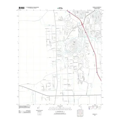
 2012 New Smyrna Beach OE E2012 Print · USGSCovers New Smyrna Beach, including Volusia County, United States, and other nearby areas
 - 2012 Map of New Smyrna Beach, 2012 Print
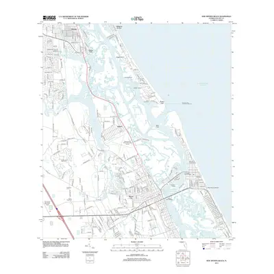 2012 New Smyrna Beach2012 Print · USGSCovers New Smyrna Beach, including Ponce Inlet, Coastal Woods, and other nearby areas
 - 2012 Map of Edgewater, 2012 Print
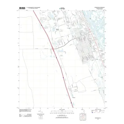 2012 Edgewater2012 Print · USGSCovers New Smyrna Beach, including Edgewater, Hucomer, and other nearby areas
Showing maps 1-25 of 50
Frequently asked questions
- What are the different types of historical maps available for New Smyrna Beach?
- What is the oldest map of New Smyrna Beach?
- Where can I purchase historical maps of New Smyrna Beach for my home or office?
- Where can I download high-res historical maps of New Smyrna Beach?
- Are there historical topographic maps available for New Smyrna Beach?
- Is there historical aerial imagery available for New Smyrna Beach?
- Where are historical maps of New Smyrna Beach sourced from?