1900s (20th Century) Maps of Sopchoppy, Florida
Explore 10 historic maps of Sopchoppy from the 1900s (20th Century). These maps offer a rare glimpse into what life looked like during the 1900s — showing old roads, neighborhoods, homes, and landmarks that have changed or disappeared over time.
Whether you're researching your family's past, planning a metal detecting trip, or studying how Sopchoppy's landscape evolved across the 1900s, these high-resolution maps are a powerful tool for exploring the history of this region.
- Focus on a specific era: All maps on this page are from the 1900s, giving you a focused view of this time period.
- See what’s changed: Compare century-old streets, trails, and buildings to today's modern landscape using overlays and satellite layers.
- Research with precision: Use these maps for genealogy, historical research, land use analysis, or educational projects.
- View, download, or print: Maps are fully viewable online in high resolution, and can be downloaded or printed for your own records.
Start exploring Sopchoppy's history through authentic maps from the 1900s. This is your window into the past.
Sopchoppy, FL maps
(10)- 1940 Map of Arran, 1966 Print
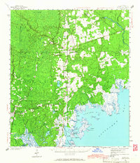 1940 Arran1966 Print · USGSWakulla County's coastal forests and rail-linked settlements are captured here in the era just before the Second World War. Researchers can locate family landmarks like Roddenberry Cem, the historic Wakulla Springs, and rural hubs such as Sopchoppy and Panacea.
 - 1943 Map of Arran
 1943 Arran1943 Print · USGSWakulla County's coastal lowlands and timber forests are captured here just before the mid-century, centered on CRAWFORDVILLE and the Seaboard Air Line. Genealogists can trace family footprints at Roddenberry Cem, Pilgrims Rest Ch, and the rural Mt Pleasant Sch.2 unique versions available
 - 1945 Map of Sanborn
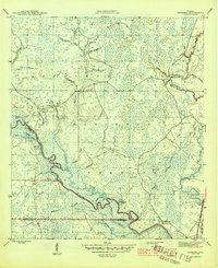 1945 Sanborn1945 Print · USGSThe river bottomlands and pine forests of Wakulla and Liberty counties are shown here just as the war ended. Researchers can trace family sites like Sanborn, find the Mt Beeser Church, and locate the West Sopchoppy Cemetery and Curtis Mill.3 unique versions available
 - 1954 Map of Tallahassee, 1967 Print
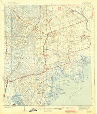
 1954 Tallahassee1967 Print · USGSThe Florida Panhandle and South Georgia are captured here during a period of mid-century growth and military expansion. Researchers can trace the development of Panama City, the footprint of Tyndall Air Force Base, and the rail lines of the Atlantic Coast Line.4 unique versions available
 - 1959 Map of Tallahassee
 1959 Tallahassee1959 Print · USGSFlorida's Panhandle and the Big Bend region appear here in the mid-fifties, showing a landscape defined by its great river systems and developing coast. Trace the early layout of Panama City, the expansive Apalachicola National Forest, and the coastal St Marks Lighthouse.
 - 1960 Map of Tallahassee
 1960 Tallahassee1960 Print · USGSThe Florida Panhandle and southern Georgia are captured here in the mid-twentieth century, showing a region defined by its rivers and military installations. Genealogists and historians can trace the growth of Tallahassee or locate coastal landmarks like the St Marks Lighthouse and Tyndall Air Force Base.
 - 1972 Map of Sopchoppy, 1973 Print
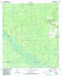
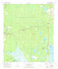 1972 Sopchoppy1973 Print · USGSCoastal Wakulla County comes into focus in the early seventies, showing the transition from the Apalachicola National Forest to the Gulf marshes. Genealogists and locals can trace family landmarks like Simmons Cem or the rural settlements of Sopchoppy and Panacea.2 unique versions available
 - 1979 Map of Tallahassee, 1980 Print
 1979 Tallahassee1980 Print · USGSFlorida's capital and the Gulf coast are captured here in the late seventies, showing the region's balance between urban growth and massive protected wetlands. Researchers can trace the routes of the Apalachicola Northern Railroad or locate small inland hubs like Sopchoppy, Panacea, and Hosford.
 - 1988 Map of Tallahassee
 1988 Tallahassee1988 Print · USGSThe Florida Panhandle and South Georgia are captured here in the late eighties, showing the expansion of the regional highway network and coastal growth. Genealogists and historians can trace rail lines like the Seaboard System Railroad or locate family roots in Blountstown, Graceville, or Crawfordville.2 unique versions available
 - 1990 Map of Sanborn
 1990 Sanborn1990 Print · USGSThe Sopchoppy and Ochlockonee rivers converge in the Florida panhandle during the late twentieth century. Genealogists can trace family names at Revell Cemetery and McKenzie-Sanborn Cemetery or locate the settlements of Sopchoppy and Curtis Mill.
End of results
Showing maps 1-10 of 10
Top cities near Sopchoppy
Frequently asked questions
- What are the different types of historical maps available for Sopchoppy?
- What is the oldest map of Sopchoppy?
- Where can I purchase historical maps of Sopchoppy for my home or office?
- Where can I download high-res historical maps of Sopchoppy?
- Are there historical topographic maps available for Sopchoppy?
- Is there historical aerial imagery available for Sopchoppy?
- Where are historical maps of Sopchoppy sourced from?