Old Maps of Crystal Lake, Florida
Explore 13 old maps of Crystal Lake, spanning from 1944 to today. These high-resolution historic maps reveal how streets, neighborhoods, landmarks, and natural features evolved over time — perfect for genealogy, metal detecting, research, and local history exploration.
What you can do with these maps:
- See how Crystal Lake changed over time: Compare historical maps to modern-day views to trace roads, homesites, rail lines & more.
- View detailed metadata: Each map includes creators, publishers, year, scale, and archive source.
- Overlay maps with satellite & LiDAR: Visualize the past alongside modern tools to explore terrain & human change.
- Trusted historical sources: Maps sourced from the USGS, Library of Congress, and other archives.
- Access maps your way: View online, download high-res files, or order prints for personal or research use.
Start exploring old maps of Crystal Lake to uncover forgotten places, hidden landmarks, and the deep history beneath your feet.
Crystal Lake, FL maps
(13)- 1944 Map of Crystal Lake, 1964 Print
 1944 Crystal Lake1964 Print · USGSIn the Florida panhandle during the mid-1940s, this area showcases a landscape of countless named ponds and lakes along the Washington Co Bay Co line. Trace the routes of the C C C Road and locate family-named features like Tyson Lake and Brit Lake.
 - 1945 Map of Crystal Lake
 1945 Crystal Lake1945 Print · USGSThe Florida Panhandle on the border of Washington and Bay counties is captured here in the mid-1940s, showcasing a unique landscape of sinkhole lakes and backwoods trails. Researchers can trace early routes like the C C C Road and locate family-named features such as Tyson Lake, Brit Lake, and Crystal Lake.3 unique versions available
 - 1954 Map of Tallahassee, 1967 Print
 1954 Tallahassee1967 Print · USGSThe Florida Panhandle and South Georgia are captured here during a period of mid-century growth and military expansion. Researchers can trace the development of Panama City, the footprint of Tyndall Air Force Base, and the rail lines of the Atlantic Coast Line.4 unique versions available
 - 1959 Map of Tallahassee
 1959 Tallahassee1959 Print · USGSFlorida's Panhandle and the Big Bend region appear here in the mid-fifties, showing a landscape defined by its great river systems and developing coast. Trace the early layout of Panama City, the expansive Apalachicola National Forest, and the coastal St Marks Lighthouse.
 - 1960 Map of Tallahassee
 1960 Tallahassee1960 Print · USGSThe Florida Panhandle and southern Georgia are captured here in the mid-twentieth century, showing a region defined by its rivers and military installations. Genealogists and historians can trace the growth of Tallahassee or locate coastal landmarks like the St Marks Lighthouse and Tyndall Air Force Base.
 - 1981 Map of Panama City
 1981 Panama City1981 Print · USGSPanama City and the Florida Panhandle coast are captured here in the early eighties, showing the region's balance of military installations and maritime industry. Researchers can trace the Atlanta and St Andrews Bay RR or locate coastal sites like Tyndall Air Force Base and Dead Lake.2 unique versions available
 - 1982 Map of Crystal Lake, 1983 Print
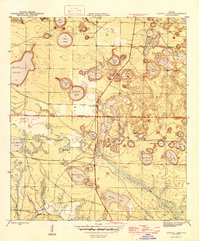
 1982 Crystal Lake1983 Print · USGSThe Florida Panhandle's lake-dotted interior is revealed in the early eighties as a complex network of sinkhole basins and timber tracts. Researchers can trace the secluded Landing Strip and named waters like Court Martial Lake, Compass Lake, and White Western Lake.2 unique versions available
 - 1988 Map of Tallahassee
 1988 Tallahassee1988 Print · USGSThe Florida Panhandle and South Georgia are captured here in the late eighties, showing the expansion of the regional highway network and coastal growth. Genealogists and historians can trace rail lines like the Seaboard System Railroad or locate family roots in Blountstown, Graceville, or Crawfordville.2 unique versions available
 - 2012 Map of Crystal Lake, 2012 Print
 2012 Crystal Lake2012 Print · USGSCovers Crystal Lake, including Bay County, Washington County, and other nearby areas
 - 2015 Map of Crystal Lake, 2015 Print
 2015 Crystal Lake2015 Print · USGSCovers Crystal Lake, including Bay County, Washington County, and other nearby areas
 - 2018 Map of Crystal Lake, 2018 Print
 2018 Crystal Lake2018 Print · USGSCovers Crystal Lake, including Bay County, Washington County, and other nearby areas
 - 2021 Map of Crystal Lake, 2021 Print
 2021 Crystal Lake2021 Print · USGSCovers Crystal Lake, including Bay County, Washington County, and other nearby areas
 - 2024 Map of Crystal Lake, 2024 Print
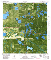
 2024 Crystal Lake2024 Print · USGSThe lake-dotted interior of Bay County is showcased here in the early twenty-first century, showing a landscape defined by sinkholes and rural ranching. Researchers can locate family landmarks like Blue Pond Cem, Paul Cem, and private airstrips such as the Stock Island Airport.
End of results
Showing maps 1-13 of 13
Top cities near Crystal Lake
- Panama City historical maps
- Lynn Haven historical maps
- Panama City Beach historical maps
- Vernon historical maps
- Wausau historical maps
- Ebro historical maps
Frequently asked questions
- What are the different types of historical maps available for Crystal Lake?
- What is the oldest map of Crystal Lake?
- Where can I purchase historical maps of Crystal Lake for my home or office?
- Where can I download high-res historical maps of Crystal Lake?
- Are there historical topographic maps available for Crystal Lake?
- Is there historical aerial imagery available for Crystal Lake?
- Where are historical maps of Crystal Lake sourced from?