Old Maps of Washington County, Florida for Hiking & Exploration
Hike through history with 160 historic maps of Washington County. Explore old trails, ghost towns, and forgotten backroads — perfect for outdoor adventurers and local explorers.
- Rediscover forgotten places: Map out old mining camps, roads, and footpaths that no longer exist on modern maps.
- Layer with modern tools: Combine with LiDAR or satellite views to plan hikes through historical terrain.
- Made for exploration: Popular among hikers, overlanders, and local history lovers.
Use these maps to find adventure and explore the hidden past of Washington County.
Washington County, FL maps
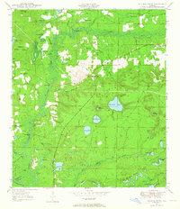
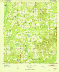
(160)- 1944 Map of Crystal Lake, 1964 Print
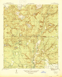
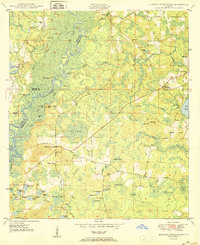
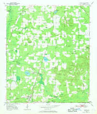
 1944 Crystal Lake1964 Print · USGSIn the Florida panhandle during the mid-1940s, this area showcases a landscape of countless named ponds and lakes along the Washington Co Bay Co line. Trace the routes of the C C C Road and locate family-named features like Tyson Lake and Brit Lake.
 - 1944 Map of Bruce, 1969 Print
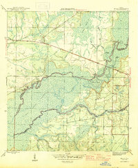
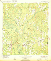
 1944 Bruce1969 Print · USGSThe Choctawhatchee River bottomlands in the 1940s reveal a landscape of remote river camps and timber landings. Trace the early footprints of Bruce and Ebro, and locate riverfront sites like Cedar Tree Landing and the Ebro Sch.
 - 1944 Map of Bennett, 1969 Print
 1944 Bennett1969 Print · USGSBay and Washington County during the mid-forties reveal a landscape of interconnected ponds and creek branches. Genealogists and local historians can trace family ties at Gainer Cem and Porter Cem or locate the rural settlement of Bennett.
 - 1945 Map of Bennett
 1945 Bennett1945 Print · USGSUpper Bay County and southern Washington County are shown here in the mid-1940s, centered on the complex drainage of the Econfina Creek valley. Genealogists can locate the Gainer Cem and trace old industrial sites like Mitchell Mill Creek near Bennett.3 unique versions available
 - 1945 Map of Red Head
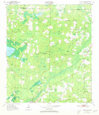
 1945 Red Head1945 Print · USGSThe Choctawhatchee River lowlands and the southern pine forests come into focus during the mid-1940s. Genealogists and local historians can locate early community hubs like Red Head and the Oak Grove Ch, or trace landmarks like the Moody Fire Tower and Ebro Cem.4 unique versions available
 - 1945 Map of Bruce
 1945 Bruce1945 Print · USGSFlorida's Panhandle river country is captured here in the mid-1940s, showing the complex wetlands where Walton and Washington Counties meet. Researchers can trace the riverfront economy through sites like Cowford Ferry, Miller Landing, and the Ebro school.3 unique versions available
 - 1945 Map of Crystal Lake
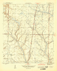
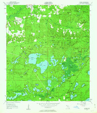
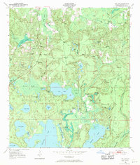
 1945 Crystal Lake1945 Print · USGSThe Florida Panhandle on the border of Washington and Bay counties is captured here in the mid-1940s, showcasing a unique landscape of sinkhole lakes and backwoods trails. Researchers can trace early routes like the C C C Road and locate family-named features such as Tyson Lake, Brit Lake, and Crystal Lake.3 unique versions available
 - 1945 Map of Fountain
 1945 Fountain1945 Print · USGSBay County during the mid-forties reveals a landscape shaped by timber interests and rural crossroads. Local researchers can trace old transportation routes like the Tramroad or locate the Youngstown Lookout Tower near Fountain.3 unique versions available
 - 1948 Map of Ponce De Leon, 1970 Print
 1948 Ponce De Leon1970 Print · USGSThe Florida Panhandle is captured here in the late 1940s, showing a landscape defined by natural springs and the crossroads of the Old Spanish Trail. Researchers can locate family landmarks like Knox Hill Sch, Hardy Cem, and the settlement of Ponce de Leon.
 - 1949 Map of Millers Ferry, 1965 Print
 1949 Millers Ferry1965 Print · USGSThe Florida Panhandle's riverine border comes to life in the late 1940s as settlements like New Hope and Millers Ferry anchor the landscape. Genealogists can trace family landmarks like Miller Cem, Wilcox Cem, and the rural Brink-Hill Sch.
 - 1949 Map of Redbay, 1968 Print
 1949 Redbay1968 Print · USGSWalton and Washington counties meet along the river bottomlands in the late 1940s. Genealogists can trace family landmarks like Redbay Cem, Bruce Creek Sch, and the riverside Story Landing.
 - 1949 Map of Hinsons Cross Roads, 1972 Print
 1949 Hinsons Cross Roads1972 Print · USGSFlorida Panhandle life in the late 1940s centers on the river bends and rural intersections where the boundaries of Washington, Holmes, and Walton counties meet. Researchers can trace family ties through community landmarks like Hinsons Cross Roads, Davis Sch, and New Bethany Ch.
 - 1949 Map of Caryville, 1973 Print
 1949 Caryville1973 Print · USGSThe Choctawhatchee River floodplain in the late 1940s reveals a landscape of winding sloughs and rail-side settlements. Genealogists can trace family names at Westville Cem and Dyson Cem or locate rural schools like New Prospect Sch and Union Sch.
 - 1950 Map of Millers Ferry
 1950 Millers Ferry1950 Print · USGSThe riverine corridor of the Florida Panhandle comes alive in the mid-century before major highway changes altered the local landscape. Genealogists can trace family connections at Miller Cem and locate vanished river crossings like Millers Ferry and Shell Landing Ferry.
 - 1950 Map of Ponce De Leon
 1950 Ponce De Leon1950 Print · USGSFlorida's Panhandle is captured here at mid-century, where the Louisville and Nashville railroad meets the winding Choctawhatchee River. Researchers can locate old community landmarks like Douglas Crossroad, Knox Hill Sch, and the historic Old Spanish Trail.
 - 1950 Map of Hinsons Cross Roads
 1950 Hinsons Cross Roads1950 Print · USGSFlorida's Panhandle is documented here at the midpoint of the century, showing the rural intersections of Washington, Holmes, and Walton counties. Genealogists can trace local landmarks like St Matthews Ch, Clarkston Cem, and the community at Hinsons Cross Roads.
 - 1950 Map of Redbay
 1950 Redbay1950 Print · USGSThe Choctawhatchee River corridor in the mid-century remains a landscape of dense swamps and small upland settlements. Local researchers can trace family landmarks and burial sites like Redbay Cem, Dead River Cem, and the river landing at Story Landing.
 - 1950 Map of Caryville
 1950 Caryville1950 Print · USGSThe Choctawhatchee River lowlands come to life in this 1950s survey of the Holmes and Washington border. Genealogists can locate family landmarks like Blackman Cem, Forehand Cem, and schools in Gritney or Winterville.
 - 1950 Map of Vernon, 1963 Print
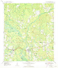
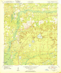
 1950 Vernon1963 Print · USGSIn the mid-century Florida panhandle, this area of Washington County centers on the winding Holmes Creek and a dense network of rural communities. Researchers can locate several historical schools and churches, including Moss Hill Ch, Greenhead Sch, and Tiller Cem.2 unique versions available
 - 1950 Map of Chipley, 1966 Print
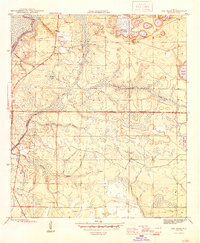
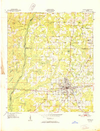
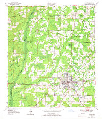 1950 Chipley1966 Print · USGSMid-century Florida panhandle life unfolds in this survey of the region where the railroad meets the Old Spanish Trail. Genealogists and historians can trace the rural landscape through Richter Crossroads, Mt Zion Cem, and the Chipley Landing Field.
 - 1950 Map of Wausau, 1968 Print
 1950 Wausau1968 Print · USGSWashington County during the early post-war years reveals a landscape of dispersed farmsteads and rural schoolhouses. Genealogists can locate family landmarks such as Bells Mill, Orange Hill Corners, and several rural burial grounds like Bradford Cem.
 - 1950 Map of Gap Lake, 1971 Print
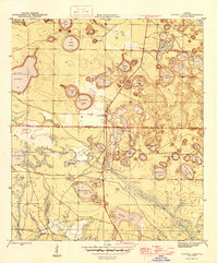
 1950 Gap Lake1971 Print · USGSFlorida's Panhandle is shown here in the early fifties, a landscape of intricate cypress swamps and rural pine woods. Genealogists can trace family landmarks like Deadening Cem, White Oak Ch, and the small settlement of Daniels.
 - 1950 Map of Poplar Head, 1973 Print
 1950 Poplar Head1973 Print · USGSMid-century Washington and Holmes Counties are defined here by the winding Holmes Creek and a labyrinth of timbered bays. Genealogists can locate family landmarks like Johnson Crossroad, Union Hill Sch, and the Bethesda Ch.
 - 1951 Map of Chipley
 1951 Chipley1951 Print · USGSChipley and its surrounding wetlands are captured here at the start of the 1950s, showing a landscape defined by the railroad and the Old Spanish Trail. Genealogists and local historians can locate early family landmarks like Richter Crossroads, Salem Ch, and Mt Zion Cem.
 - 1951 Map of Wausau
 1951 Wausau1951 Print · USGSFlorida's Panhandle is documented here in the early fifties, showing the rural communities of Washington and Holmes counties before modern development. Researchers can trace ancestral roots through sites like Everett Cem, Oak Grove Sch, and the community of Wausau.
Showing maps 1-25 of 160
Top cities of Washington County
- Chipley historical maps
- Vernon historical maps
- Wausau historical maps
- Ebro historical maps
- Caryville historical maps
Frequently asked questions
- What are the different types of historical maps available for Washington County?
- What is the oldest map of Washington County?
- Where can I purchase historical maps of Washington County for my home or office?
- Where can I download high-res historical maps of Washington County?
- Are there historical topographic maps available for Washington County?
- Is there historical aerial imagery available for Washington County?
- Where are historical maps of Washington County sourced from?