1970s Maps of Milledgeville, Georgia
Explore 4 historic maps of Milledgeville from the 1970s. These maps offer a rare glimpse into what life looked like during the 1970s — showing old roads, neighborhoods, homes, and landmarks that have changed or disappeared over time.
Whether you're researching your family's past, planning a metal detecting trip, or studying how Milledgeville's landscape evolved across the 1970s, these high-resolution maps are a powerful tool for exploring the history of this region.
- Focus on a specific era: All maps on this page are from the 1970s, giving you a focused view of this time period.
- See what’s changed: Compare century-old streets, trails, and buildings to today's modern landscape using overlays and satellite layers.
- Research with precision: Use these maps for genealogy, historical research, land use analysis, or educational projects.
- View, download, or print: Maps are fully viewable online in high resolution, and can be downloaded or printed for your own records.
Start exploring Milledgeville's history through authentic maps from the 1970s. This is your window into the past.
Milledgeville, GA maps
(4)- 1972 Map of Browns Crossing, 1975 Print
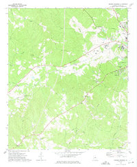 1972 Browns Crossing1975 Print · USGSMiddle Georgia's western Baldwin County transitions from rural creek basins to institutional centers in the early 1970s. Genealogists and historians can trace community roots through numerous landmarks like Browns Crossing, Antioch Ch, and the State Training School for Boys.2 unique versions available
 - 1972 Map of Lake Sinclair West, 1975 Print
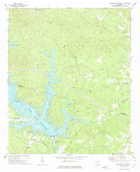
 1972 Lake Sinclair West1975 Print · USGSThe confluence of the Oconee and Little Rivers in the early seventies shows a landscape transformed by power generation and lakeside growth. Researchers can locate rural landmarks like Rooty Creek Ch, the Central of Georgia rail line, and the John Milledge Academy.
 - 1972 Map of Lake Sinclair East, 1975 Print
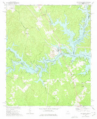
 1972 Lake Sinclair East1975 Print · USGSThe shorelines of Lake Sinclair in the early seventies reveal a landscape transitioning between rural heritage and new industrial utility. Researchers can trace local landmarks like Island Creek Ch and Walls Cem or locate the Powerplant near Carter Island.2 unique versions available
 - 1972 Map of Milledgeville, 1975 Print
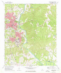 1972 Milledgeville1975 Print · USGSMilledgeville and the Oconee River valley are captured here in the early seventies, showcasing a landscape defined by prominent state institutions and schools. Genealogists and historians can trace State Hospital grounds and local landmarks like Memory Hill Cem and Fort Wilkinson Historical Site.3 unique versions available
End of results
Showing maps 1-4 of 4
Top cities near Milledgeville
- Eatonton historical maps
- Hardwick historical maps
- Gordon historical maps
- Ivey historical maps
- Crooked Creek historical maps
Top neighborhoods of Milledgeville
Frequently asked questions
- What are the different types of historical maps available for Milledgeville?
- What is the oldest map of Milledgeville?
- Where can I purchase historical maps of Milledgeville for my home or office?
- Where can I download high-res historical maps of Milledgeville?
- Are there historical topographic maps available for Milledgeville?
- Is there historical aerial imagery available for Milledgeville?
- Where are historical maps of Milledgeville sourced from?