1900s (20th Century) Maps of Greenbriar, Cartersville
Explore 9 historic maps of Greenbriar from the 1900s (20th Century). These maps offer a rare glimpse into what life looked like during the 1900s — showing old roads, neighborhoods, homes, and landmarks that have changed or disappeared over time.
Whether you're researching your family's past, planning a metal detecting trip, or studying how Greenbriar's landscape evolved across the 1900s, these high-resolution maps are a powerful tool for exploring the history of this region.
- Focus on a specific era: All maps on this page are from the 1900s, giving you a focused view of this time period.
- See what’s changed: Compare century-old streets, trails, and buildings to today's modern landscape using overlays and satellite layers.
- Research with precision: Use these maps for genealogy, historical research, land use analysis, or educational projects.
- View, download, or print: Maps are fully viewable online in high resolution, and can be downloaded or printed for your own records.
Start exploring Greenbriar's history through authentic maps from the 1900s. This is your window into the past.
Greenbriar, Cartersville maps
(9)- 1906 Map of Stilesboro, 1971 Print
 1906 Stilesboro1971 Print · USGSBartow County at the turn of the century was a bustling nexus of rail and river commerce before the modern highway era. Genealogists and historians can trace the foundations of Cartersville and find rural landmarks like Euharlee Ch, Malbone, and Petrobutte PO.
 - 1908 Map of Stilesboro
 1908 Stilesboro1908 Print · USGSBartow County's industrial and agricultural landscape at the turn of the century is defined by its busy rail junctions and the winding Etowah River. Genealogists and historians can trace the early road networks and rail stops from Cartersville to Stilesboro, finding named points like Rogers Ferrobutte PO and Harden Bridge.
 - 1955 Map of Rome
 1955 Rome1955 Print · USGSThe tri-state borderlands of Georgia, Alabama, and Tennessee appear in the mid-fifties as a landscape of ridge-and-valley industry and river navigation. Genealogists can trace family footprints near Chattanooga, the iron works of Gadsden, and textile towns like Trion or Summerville.
 - 1958 Map of Rome, 1966 Print
 1958 Rome1966 Print · USGSNorthwest Georgia and neighboring Tennessee and Alabama are captured here in the late fifties, showcasing a landscape of high ridges and river valleys. Researchers can trace historic rail lines like the Seaboard Air Line RR and explore the bounds of Cloudland Canyon State Park or Fort Oglethorpe.3 unique versions available
 - 1961 Map of Rome
 1961 Rome1961 Print · USGSNorthwest Georgia and neighboring Tennessee and Alabama are shown here at a moment of significant mid-century growth. Researchers can trace the rail networks of the Central of Georgia or locate landmarks within Chickamauga and Chattanooga Nat Military Park.
 - 1963 Map of Rome
 1963 Rome1963 Print · USGSThe tri-state corner of Georgia, Alabama, and Tennessee is captured here during a period of massive reservoir expansion and post-war growth. Genealogists and historians can trace the rail corridors of the Southern Ry or locate landmarks like Fort Oglethorpe and Cloudland Canyon State Park.
 - 1972 Map of Cartersville, 1974 Print
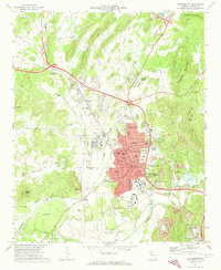 1972 Cartersville1974 Print · USGSCartersville and the Etowah River valley are shown here in the early seventies during a period of industrial and suburban expansion. Genealogists and historians can trace the foundations of Atco, locate Oak Hill Cemetery, and find Indian Mounds near the local river bends.2 unique versions available
 - 1981 Map of Cartersville, 1982 Print
 1981 Cartersville1982 Print · USGSNorth Georgia at the start of the eighties shows a landscape defined by massive reservoirs and historic rail corridors. Researchers can trace the heritage of the Etowah Indian Mounds or locate old junctions along the Southern Railway and Seaboard Coast Line.2 unique versions available
 - 1992 Map of Cartersville, 1993 Print
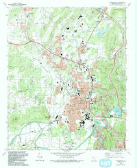 1992 Cartersville1993 Print · USGSBartow County at the start of the nineties shows a landscape of deep history and industrial change, from the Etowah River to the peaks of Dobbins Mountain. Researchers can trace old community hubs like Atco, the ancient Etowah Mounds, and family sites at Oak Hill Cemetery.
End of results
Showing maps 1-9 of 9
Frequently asked questions
- What are the different types of historical maps available for Greenbriar?
- What is the oldest map of Greenbriar?
- Where can I purchase historical maps of Greenbriar for my home or office?
- Where can I download high-res historical maps of Greenbriar?
- Are there historical topographic maps available for Greenbriar?
- Is there historical aerial imagery available for Greenbriar?
- Where are historical maps of Greenbriar sourced from?