1950s Maps of Daniel, Georgia
Explore 3 historic maps of Daniel from the 1950s. These maps offer a rare glimpse into what life looked like during the 1950s — showing old roads, neighborhoods, homes, and landmarks that have changed or disappeared over time.
Whether you're researching your family's past, planning a metal detecting trip, or studying how Daniel's landscape evolved across the 1950s, these high-resolution maps are a powerful tool for exploring the history of this region.
- Focus on a specific era: All maps on this page are from the 1950s, giving you a focused view of this time period.
- See what’s changed: Compare century-old streets, trails, and buildings to today's modern landscape using overlays and satellite layers.
- Research with precision: Use these maps for genealogy, historical research, land use analysis, or educational projects.
- View, download, or print: Maps are fully viewable online in high resolution, and can be downloaded or printed for your own records.
Start exploring Daniel's history through authentic maps from the 1950s. This is your window into the past.
Daniel, GA maps
(3)- 1950 Map of Limerick
 1950 Limerick1950 Print · USGSThe Georgia lowcountry at the mid-century mark shows a transition from coastal plantations to military and industrial expansion. Genealogists and historians can trace family roots through numerous sites like Dorchester Academy, Sunbury, and Scratchy Hall Cem.2 unique versions available
 - 1956 Map of Brunswick, 1968 Print
 1956 Brunswick1968 Print · USGSThe Georgia coast in the mid-twentieth century is a wild expanse of barrier islands and massive river deltas. You can trace the development of the maritime economy and military presence at Brunswick, or locate historic sites like Fort Frederica National Monument and Harris Neck National Wildlife Refuge.2 unique versions available
 - 1958 Map of Richmond Hill, 1961 Print
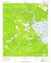 1958 Richmond Hill1961 Print · USGSCoastal Georgia in the late fifties is defined here by the winding Ogeechee and the rise of the town of Richmond Hill. Researchers can trace family history through numerous rural cemeteries and church sites, including Strathy Hall Cem, Bryan Neck Ch, and Rabbit Hill.3 unique versions available
End of results
Showing maps 1-3 of 3
Top cities near Daniel
- Savannah historical maps
- Hinesville historical maps
- Pooler historical maps
- Richmond Hill historical maps
- Georgetown historical maps
- Garden City historical maps
See more
Frequently asked questions
- What are the different types of historical maps available for Daniel?
- What is the oldest map of Daniel?
- Where can I purchase historical maps of Daniel for my home or office?
- Where can I download high-res historical maps of Daniel?
- Are there historical topographic maps available for Daniel?
- Is there historical aerial imagery available for Daniel?
- Where are historical maps of Daniel sourced from?