1960s Maps of Butts County, Georgia
Explore 6 historic maps of Butts County from the 1960s. These maps offer a rare glimpse into what life looked like during the 1960s — showing old roads, neighborhoods, homes, and landmarks that have changed or disappeared over time.
Whether you're researching your family's past, planning a metal detecting trip, or studying how Butts County's landscape evolved across the 1960s, these high-resolution maps are a powerful tool for exploring the history of this region.
- Focus on a specific era: All maps on this page are from the 1960s, giving you a focused view of this time period.
- See what’s changed: Compare century-old streets, trails, and buildings to today's modern landscape using overlays and satellite layers.
- Research with precision: Use these maps for genealogy, historical research, land use analysis, or educational projects.
- View, download, or print: Maps are fully viewable online in high resolution, and can be downloaded or printed for your own records.
Start exploring Butts County's history through authentic maps from the 1960s. This is your window into the past.
Butts County, GA maps
(6)- 1963 Map of Athens
 1963 Athens1963 Print · USGSGeorgia's Piedmont and the Savannah River valley are captured in the early sixties as major reservoirs and military installations reshaped the landscape. Researchers can trace the development of Clark Hill Reservoir, locate the Fort Gordon Military Reservation, and find historic towns like Social Circle and Eatonton.
 - 1964 Map of Lloyd Shoals Dam, 1965 Print
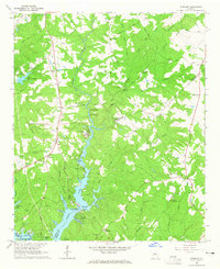
 1964 Lloyd Shoals Dam1965 Print · USGSThe convergence of the South and Alcovy Rivers into Jackson Lake defines this rural Georgia landscape in the early sixties. Genealogists can trace family names and landmarks like Leverette Cem, Bethel Grove Ch, and the settlement of Bethel.3 unique versions available
 - 1964 Map of Jackson, 1965 Print
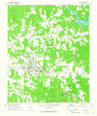 1964 Jackson1965 Print · USGSThe county seat of Jackson and the surrounding Butts County countryside are captured here in the mid-sixties as the region balanced industry and recreation. Researchers can locate family burial grounds like Etheredge Cem or visit community hubs such as Stark Ch and Flovilla.3 unique versions available
 - 1964 Map of Stewart, 1965 Print
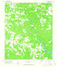
 1964 Stewart1965 Print · USGSThe convergence of the Alcovy and Yellow Rivers into Jackson Lake highlights this Georgia landscape in the 1960s. Researchers can trace family history through sites like Newton Factory and the Heard-Mixon Sch or find old burial sites such as Fincher Cem.3 unique versions available
 - 1964 Map of Locust Grove, 1965 Print
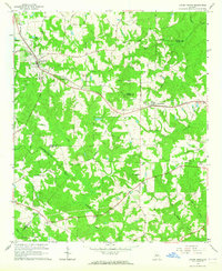 1964 Locust Grove1965 Print · USGSThe Piedmont landscape of Henry and Butts Counties is shown during the mid-sixties, centered on the railroad towns of Locust Grove and Jenkinsburg. Genealogists can trace family names at the Beersheba Cem or locate rural meeting places like England Chapel.3 unique versions available
 - 1964 Map of Worthville, 1965 Print
 1964 Worthville1965 Print · USGSThe tri-county border of Newton, Henry, and Butts comes alive in the 1960s as a landscape of rural river settlements and country churches. Genealogists can trace family roots through Rock Springs Ch, Worthville, and the Fairview Cem.2 unique versions available
End of results
Showing maps 1-6 of 6
Top cities of Butts County
Frequently asked questions
- What are the different types of historical maps available for Butts County?
- What is the oldest map of Butts County?
- Where can I purchase historical maps of Butts County for my home or office?
- Where can I download high-res historical maps of Butts County?
- Are there historical topographic maps available for Butts County?
- Is there historical aerial imagery available for Butts County?
- Where are historical maps of Butts County sourced from?