1970s Maps of Butts County, Georgia
Explore 4 historic maps of Butts County from the 1970s. These maps offer a rare glimpse into what life looked like during the 1970s — showing old roads, neighborhoods, homes, and landmarks that have changed or disappeared over time.
Whether you're researching your family's past, planning a metal detecting trip, or studying how Butts County's landscape evolved across the 1970s, these high-resolution maps are a powerful tool for exploring the history of this region.
- Focus on a specific era: All maps on this page are from the 1970s, giving you a focused view of this time period.
- See what’s changed: Compare century-old streets, trails, and buildings to today's modern landscape using overlays and satellite layers.
- Research with precision: Use these maps for genealogy, historical research, land use analysis, or educational projects.
- View, download, or print: Maps are fully viewable online in high resolution, and can be downloaded or printed for your own records.
Start exploring Butts County's history through authentic maps from the 1970s. This is your window into the past.
Butts County, GA maps
(4)- 1973 Map of Berner, 1975 Print
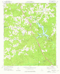
 1973 Berner1975 Print · USGSCentral Georgia's river-cut timberlands are captured here in the early seventies, showing the rural communities of Jasper and Butts counties. Genealogists and historians can trace the Southern railroad corridor through Berner and locate country congregations like Ward Ch.2 unique versions available
 - 1973 Map of High Falls, 1976 Print
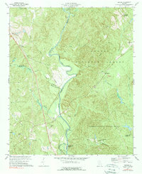
 1973 High Falls1976 Print · USGSThe Towaliga River corridor in the 1970s shows a landscape of transition between historic agricultural roots and modern recreation. Trace family history and land patterns through High Falls Lake, the Higgins Mill site, and local landmarks like Patillo and High Shoals Ch.2 unique versions available
 - 1973 Map of Indian Springs, 1976 Print
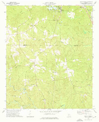 1973 Indian Springs1976 Print · USGSThe rural Georgia landscape between Flovilla and Cabaniss is captured here in the mid-1970s as agricultural life centered around a dense network of country churches. Genealogists and local historians can trace family locations near Indian Springs, St Pauls Ch, and China Grove Cem.2 unique versions available
 - 1979 Map of Griffin, 1980 Print
 1979 Griffin1980 Print · USGSWest-central Georgia at the close of the seventies reveals a landscape of historic rail towns and growing suburbs between the major river systems. Trace the rail lines and early road networks connecting Griffin, Peachtree City, and Newnan, or locate smaller settlements like Senoia and Experiment.3 unique versions available
End of results
Showing maps 1-4 of 4
Top cities of Butts County
Frequently asked questions
- What are the different types of historical maps available for Butts County?
- What is the oldest map of Butts County?
- Where can I purchase historical maps of Butts County for my home or office?
- Where can I download high-res historical maps of Butts County?
- Are there historical topographic maps available for Butts County?
- Is there historical aerial imagery available for Butts County?
- Where are historical maps of Butts County sourced from?