1910s Maps of St. Marys, Georgia
Explore 3 historic maps of St. Marys from the 1910s. These maps offer a rare glimpse into what life looked like during the 1910s — showing old roads, neighborhoods, homes, and landmarks that have changed or disappeared over time.
Whether you're researching your family's past, planning a metal detecting trip, or studying how St. Marys's landscape evolved across the 1910s, these high-resolution maps are a powerful tool for exploring the history of this region.
- Focus on a specific era: All maps on this page are from the 1910s, giving you a focused view of this time period.
- See what’s changed: Compare century-old streets, trails, and buildings to today's modern landscape using overlays and satellite layers.
- Research with precision: Use these maps for genealogy, historical research, land use analysis, or educational projects.
- View, download, or print: Maps are fully viewable online in high resolution, and can be downloaded or printed for your own records.
Start exploring St. Marys's history through authentic maps from the 1910s. This is your window into the past.
St. Marys, GA maps
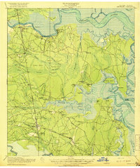
(3)- 1918 Map of St Marys
 1918 St Marys1918 Print · USGSCoastal Nassau County and the Georgia border are seen here just after the Great War, during a period of peak railroad expansion. Trace family roots and old landings at St Marys, Wild's Ferry, and the Evergreen School house.
 - 1918 Map of Kingsland
 1918 Kingsland1918 Print · USGSCamden County, Georgia, at the Florida border, is shown here during the First World War era when river landings and rail junctions shaped local life. Genealogists can trace family footprints at Ruhamah School, Fairview Church, and the riverfront settlement of Ceylon.3 unique versions available
 - 1919 Map of St Marys
 1919 St Marys1919 Print · USGSThe Georgia-Florida borderlands near the coast were a patchwork of tidal marshes and rail towns just after the Great War. You can trace early river landings and rural schools like Evergreen School, Wilds Ferry, and the Seaboard Air Line rail stops.5 unique versions available
End of results
Showing maps 1-3 of 3
Top cities near St. Marys
- Jacksonville historical maps
- Kingsland historical maps
- Fernandina Beach historical maps
- Kings Bay Base historical maps
- Woodbine historical maps
Top neighborhoods of St. Marys
- Quail Hollow historical maps
- River Oaks historical maps
- Harbor Pines historical maps
- Shadowlawn historical maps
- Admirals Walk historical maps
- Lands End historical maps
See more
Frequently asked questions
- What are the different types of historical maps available for St. Marys?
- What is the oldest map of St. Marys?
- Where can I purchase historical maps of St. Marys for my home or office?
- Where can I download high-res historical maps of St. Marys?
- Are there historical topographic maps available for St. Marys?
- Is there historical aerial imagery available for St. Marys?
- Where are historical maps of St. Marys sourced from?