1970s Maps of St. Marys, Georgia
Explore 2 historic maps of St. Marys from the 1970s. These maps offer a rare glimpse into what life looked like during the 1970s — showing old roads, neighborhoods, homes, and landmarks that have changed or disappeared over time.
Whether you're researching your family's past, planning a metal detecting trip, or studying how St. Marys's landscape evolved across the 1970s, these high-resolution maps are a powerful tool for exploring the history of this region.
- Focus on a specific era: All maps on this page are from the 1970s, giving you a focused view of this time period.
- See what’s changed: Compare century-old streets, trails, and buildings to today's modern landscape using overlays and satellite layers.
- Research with precision: Use these maps for genealogy, historical research, land use analysis, or educational projects.
- View, download, or print: Maps are fully viewable online in high resolution, and can be downloaded or printed for your own records.
Start exploring St. Marys's history through authentic maps from the 1970s. This is your window into the past.
St. Marys, GA maps
(2)- 1979 Map of St. Marys, 1980 Print
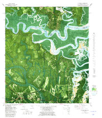 1979 St. Marys1980 Print · USGSThe Georgia-Florida border comes alive in the late seventies as the tidal marshlands meet the growing grid of St. Marys. Researchers can trace old family settlements and local landmarks like Oak Grove Cem, Chester, and the Seaboard Coast Line.2 unique versions available
 - 1979 Map of Gross, 1980 Print
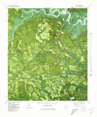 1979 Gross1980 Print · USGSNassau County, Florida, sits at the Georgia border in the late seventies, where the St Marys River winds through a landscape of timber and swamp. Genealogists can locate small rural centers like Evergreen and Gross, alongside old landmarks like St James Ch and the Seaboard Coast Line railway.
End of results
Showing maps 1-2 of 2
Top cities near St. Marys
- Jacksonville historical maps
- Kingsland historical maps
- Fernandina Beach historical maps
- Kings Bay Base historical maps
- Woodbine historical maps
Top neighborhoods of St. Marys
- Quail Hollow historical maps
- River Oaks historical maps
- Harbor Pines historical maps
- Shadowlawn historical maps
- Admirals Walk historical maps
- Lands End historical maps
See more
Frequently asked questions
- What are the different types of historical maps available for St. Marys?
- What is the oldest map of St. Marys?
- Where can I purchase historical maps of St. Marys for my home or office?
- Where can I download high-res historical maps of St. Marys?
- Are there historical topographic maps available for St. Marys?
- Is there historical aerial imagery available for St. Marys?
- Where are historical maps of St. Marys sourced from?