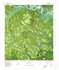
1979 Map of Gross
USGS Topo · Published 1980About this map
The St Marys River meanders along the border of Georgia and Florida, defining the northern edge of this landscape where Nassau County meets Camden County. During the late 1970s, the area around Gross remained largely dominated by dense wetlands and watercourses, including McQueen Swamp, White Oak Swamp, and Plummer Swamp. This terrain necessitated a transit-focused settlement pattern, with the Seaboard Coast Line railroad and local roads like Wingate Landing Road providing vital connections through the lowlands.
Find a feature on this map
23 named features on this map. Tap any name to fly to it.
Don’t see what you’re looking for? This feature index may not catch every label — zoom into the map to look around manually.
Map Details
Editions of this 1979 Gross Map
This is the sole edition of this map. No revisions or reprints were ever made.
Other maps of this area

1917 · Boulogne
USGS Topo · 1:62,500

1917 · Hilliard
USGS Topo · 1:62,500

1918 · St Marys
USGS Topo · 1:62,500

1918 · Kingsland
USGS Topo · 1:62,500

1919 · St Marys
USGS Topo · 1:62,500

1919 · Hilliard
USGS Topo · 1:62,500

1919 · Boulogne
USGS Topo · 1:62,500

1948 · Jacksonville
USGS Topo · 1:250,000

1957 · Jacksonville
USGS Topo · 1:250,000

1958 · Gross
USGS Topo · 1:24,000