
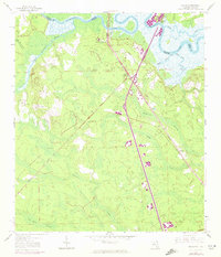
1958 Map of Gross
USGS Topo · Published 1959About this map
The St Marys River forms a winding natural border between Florida and Georgia, defining the northern landscape of this late 1950s survey. Much of the terrain is dominated by vast, interconnected wetlands, including Plummer Swamp, McQueen Swamp, and Tom Mann Swamp, which illustrate the low-lying coastal plain environment. Human settlement is largely concentrated along the Seaboard Air Line Railroad corridor, which cuts a sharp diagonal through the forest and marshland. Small communities such as Gross and Becker provide insight into the region's rail-dependent growth during this era.
Find a feature on this map
23 named features on this map. Tap any name to fly to it.
Don’t see what you’re looking for? This feature index may not catch every label — zoom into the map to look around manually.
Map Details
Editions of this 1958 Gross Map
2 editions found
Other maps of this area

1917 · Boulogne
USGS Topo · 1:62,500

1917 · Hilliard
USGS Topo · 1:62,500

1918 · St Marys
USGS Topo · 1:62,500

1918 · Kingsland
USGS Topo · 1:62,500

1919 · St Marys
USGS Topo · 1:62,500

1919 · Hilliard
USGS Topo · 1:62,500

1919 · Boulogne
USGS Topo · 1:62,500

1948 · Jacksonville
USGS Topo · 1:250,000

1957 · Jacksonville
USGS Topo · 1:250,000
1958 · Harrietts Bluff
USGS Topo · 1:24,000