1970s Maps of Carrollton, Georgia
Explore 3 historic maps of Carrollton from the 1970s. These maps offer a rare glimpse into what life looked like during the 1970s — showing old roads, neighborhoods, homes, and landmarks that have changed or disappeared over time.
Whether you're researching your family's past, planning a metal detecting trip, or studying how Carrollton's landscape evolved across the 1970s, these high-resolution maps are a powerful tool for exploring the history of this region.
- Focus on a specific era: All maps on this page are from the 1970s, giving you a focused view of this time period.
- See what’s changed: Compare century-old streets, trails, and buildings to today's modern landscape using overlays and satellite layers.
- Research with precision: Use these maps for genealogy, historical research, land use analysis, or educational projects.
- View, download, or print: Maps are fully viewable online in high resolution, and can be downloaded or printed for your own records.
Start exploring Carrollton's history through authentic maps from the 1970s. This is your window into the past.
Carrollton, GA maps
(3)- 1973 Map of Temple, 1975 Print
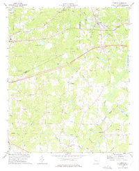 1973 Temple1975 Print · USGSTemple and Bremen were regional hubs in the early 1970s as the rail and road networks expanded through Georgia. Local historians can trace family roots through numerous landmark churches and schools like Miller Academy, Old Concord Ch, and Liberty Cem.2 unique versions available
 - 1973 Map of Bowdon East, 1975 Print
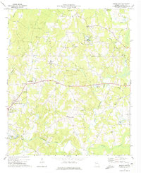 1973 Bowdon East1975 Print · USGSCarroll County’s rolling landscape is captured in the early seventies, showing a community defined by its riverbanks and rural crossroads. Genealogists and local historians can trace family roots through numerous sites like Pine Tucky Ch, Farmers High, and the grounds of John Tanner State Park.2 unique versions available
 - 1973 Map of Carrollton, 1975 Print
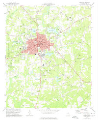 1973 Carrollton1975 Print · USGSCarrollton was thriving in the early seventies as the regional seat and home to a growing college campus. Researchers can trace the Central of Georgia rail line past Clem or locate local landmarks like West Georgia College and Shiloh Ch.3 unique versions available
End of results
Showing maps 1-3 of 3
Top cities near Carrollton
- Villa Rica historical maps
- Bremen historical maps
- Tallapoosa historical maps
- Bowdon historical maps
- Mount Zion historical maps
- Buchanan historical maps
See more
Top neighborhoods of Carrollton
- Riverbend historical maps
- Lamplighter Square historical maps
- Briarwood Estates historical maps
- Holly Heights historical maps
- Land-O-Plenty Subdivision historical maps
Frequently asked questions
- What are the different types of historical maps available for Carrollton?
- What is the oldest map of Carrollton?
- Where can I purchase historical maps of Carrollton for my home or office?
- Where can I download high-res historical maps of Carrollton?
- Are there historical topographic maps available for Carrollton?
- Is there historical aerial imagery available for Carrollton?
- Where are historical maps of Carrollton sourced from?