1980s Maps of Charlton County, Georgia
Explore 6 historic maps of Charlton County from the 1980s. These maps offer a rare glimpse into what life looked like during the 1980s — showing old roads, neighborhoods, homes, and landmarks that have changed or disappeared over time.
Whether you're researching your family's past, planning a metal detecting trip, or studying how Charlton County's landscape evolved across the 1980s, these high-resolution maps are a powerful tool for exploring the history of this region.
- Focus on a specific era: All maps on this page are from the 1980s, giving you a focused view of this time period.
- See what’s changed: Compare century-old streets, trails, and buildings to today's modern landscape using overlays and satellite layers.
- Research with precision: Use these maps for genealogy, historical research, land use analysis, or educational projects.
- View, download, or print: Maps are fully viewable online in high resolution, and can be downloaded or printed for your own records.
Start exploring Charlton County's history through authentic maps from the 1980s. This is your window into the past.
Charlton County, GA maps
(6)- 1980 Map of Okefenokee Swamp, 1981 Print
 1980 Okefenokee Swamp1981 Print · USGSThe Georgia-Florida borderlands come to life in the early 1980s, centered on the immense wilderness of the Okefenokee Swamp. Genealogists and historians can trace rail-stop settlements like Fargo and Fruitland or explore the interior geography of Billys Island and Trail Ridge.
 - 1981 Map of Lake City
 1981 Lake City1981 Print · USGSNorth Florida and South Georgia are mapped in the early eighties as the region balanced forestry with growing infrastructure. Genealogists can trace family names and locations from Live Oak to Macclenny, or find cultural landmarks like the Stephen Foster State Folk Culture Center.2 unique versions available
 - 1981 Map of Fernandina Beach, 1982 Print
 1981 Fernandina Beach1982 Print · USGSThe coastal borderlands of Georgia and Florida are captured here in the early eighties, from the barrier islands to the rail towns of the interior. Genealogists and historians can trace family-named bluffs and sites like Franklintown, Dungeness Wharf, and St Marys Historical Park.3 unique versions available
 - 1981 Map of Brunswick, 1982 Print
 1981 Brunswick1982 Print · USGSThe Georgia coast at the start of the eighties reveals a complex landscape of tidal estuaries, deep-water sounds, and growing island communities. Trace local history through the protected grounds of Fort Frederica National Monument and the old rail stops at Thalmann and Nahunta.3 unique versions available
 - 1988 Map of Waycross
 1988 Waycross1988 Print · USGSSouth Georgia's wiregrass and timber country is documented here in the late eighties, centered on the vital rail junction of Waycross. Genealogists and historians can trace the rural landscape from Okefenokee up to the Ocmulgee, finding sites like Lumber City and Jefferson Davis Memorial State Park.
 - 1988 Map of Jacksonville
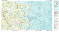
 1988 Jacksonville1988 Print · USGSCoastal Florida and Georgia are captured here during the late eighties, documenting the rapid growth of the First Coast and its vital military installations. Researchers can trace the development of beach communities like Fernandina Beach and Atlantic Beach or locate family landmarks near Mickler Landing and Orange Park.
End of results
Showing maps 1-6 of 6
Top cities of Charlton County
Frequently asked questions
- What are the different types of historical maps available for Charlton County?
- What is the oldest map of Charlton County?
- Where can I purchase historical maps of Charlton County for my home or office?
- Where can I download high-res historical maps of Charlton County?
- Are there historical topographic maps available for Charlton County?
- Is there historical aerial imagery available for Charlton County?
- Where are historical maps of Charlton County sourced from?