1950s Maps of Sharon Park, Garden City
Explore 2 historic maps of Sharon Park from the 1950s. These maps offer a rare glimpse into what life looked like during the 1950s — showing old roads, neighborhoods, homes, and landmarks that have changed or disappeared over time.
Whether you're researching your family's past, planning a metal detecting trip, or studying how Sharon Park's landscape evolved across the 1950s, these high-resolution maps are a powerful tool for exploring the history of this region.
- Focus on a specific era: All maps on this page are from the 1950s, giving you a focused view of this time period.
- See what’s changed: Compare century-old streets, trails, and buildings to today's modern landscape using overlays and satellite layers.
- Research with precision: Use these maps for genealogy, historical research, land use analysis, or educational projects.
- View, download, or print: Maps are fully viewable online in high resolution, and can be downloaded or printed for your own records.
Start exploring Sharon Park's history through authentic maps from the 1950s. This is your window into the past.
Sharon Park, Garden City maps
(2)- 1955 Map of Garden City, 1957 Print
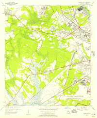 1955 Garden City1957 Print · USGSGarden City and the western outskirts of Savannah are shown here during a period of rapid aviation and rail expansion in the mid-fifties. Genealogists and historians can locate family landmarks like Silk Hope, the Lincoln Memorial Cem, and early recreational sites such as the Oglethorpe Speedway.2 unique versions available
 - 1957 Map of Savannah, 1967 Print
 1957 Savannah1967 Print · USGSThe Lowcountry and Georgia coastal plain are shown here in the late fifties, prior to modern expansion. Researchers can trace the rail-and-river economy through the Central of Georgia lines and the Ogeechee River wetlands.4 unique versions available
End of results
Showing maps 1-2 of 2
Top cities near Sharon Park
- Savannah historical maps
- Pooler historical maps
- Richmond Hill historical maps
- Wilmington Island historical maps
- Georgetown historical maps
- Garden City historical maps
See more
Frequently asked questions
- What are the different types of historical maps available for Sharon Park?
- What is the oldest map of Sharon Park?
- Where can I purchase historical maps of Sharon Park for my home or office?
- Where can I download high-res historical maps of Sharon Park?
- Are there historical topographic maps available for Sharon Park?
- Is there historical aerial imagery available for Sharon Park?
- Where are historical maps of Sharon Park sourced from?