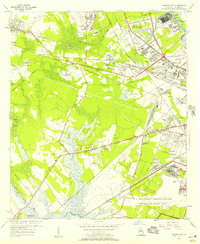
1955 Map of Garden City
USGS Topo · Published 1957About this map
Travis Field and the surrounding industrial corridors of Garden City dominate the landscape in the mid-1950s, revealing a complex network of logistics and transport outside of Savannah. This survey illustrates the dense convergence of rail lines such as the Seaboard Air Line and Central of Georgia, which serviced the growing suburban developments of Chatham City, Wheat Hill, and Woodville. The southern portion of the quadrangle transitions into the marshes of the Little Ogeechee River, where landmarks like the Savannah Lookout Tower and Silk Hope stand alongside the sprawling U S Military Reservation Hunter Air Force Base. Historic infrastructure like the Savannah and Ogeechee Canal remains visible, cutting across the terrain toward Culvert Swamp. Local community life is anchored by numerous small parishes and schools, including Antioch Sch and the Bible Institute, reflecting the early post-war expansion of Chatham County.
Find a feature on this map
69 named features on this map. Tap any name to fly to it.
Don’t see what you’re looking for? This feature index may not catch every label — zoom into the map to look around manually.
Map Details
Editions of this 1955 Garden City Map
2 editions found
Other maps of this area

1920 · Meldrim
USGS Topo · 1:62,500

1920 · Limerick
USGS Topo · 1:62,500

1942 · Meldrim
USGS Topo · 1:62,500

1942 · Savannah
USGS Topo · 1:62,500

1944 · Limerick
USGS Topo · 1:62,500

1944 · Ossabaw Island
USGS Topo · 1:62,500

1945 · Ossabaw Island
USGS Topo · 1:62,500

1946 · Brunswick
USGS Topo · 1:250,000

1947 · Savannah
USGS Topo · 1:250,000

1948 · Brunswick
USGS Topo · 1:250,000