
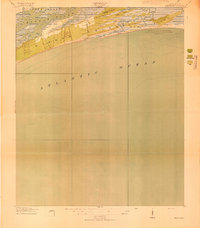
1947 Map of Savannah
USGS Topo · Published 1947About this map
The coastal marshlands and river systems of the Lowcountry define this landscape just after World War II, showing a region where tide-water commerce and military preparations converged. Savannah serves as the primary urban hub, connected by the Savannah River to a network of inland rail lines including the Atlantic Coast Line and Seaboard Air Line. This era captures a period of significant military activity, with large installations like Camp Stewart, Chatham AAF, and the U S Marine Base on Parris Island deeply integrated into the geography of Chatham and Beaufort counties.
Find a feature on this map
278 named features on this map. Tap any name to fly to it.
Don’t see what you’re looking for? This feature index may not catch every label — zoom into the map to look around manually.
Map Details
Editions of this 1947 Savannah Map
This is the sole edition of this map. No revisions or reprints were ever made.
Other maps of this area

1918 · Walterboro
USGS Topo · 1:62,500
1918 · Kiawah Island
USGS Topo · 1:21,120

1918 · Hinesville
USGS Topo · 1:62,500

1918 · Green Pond
USGS Topo · 1:62,500

1918 · Varnville
USGS Topo · 1:62,500

1918 · Yemassee
USGS Topo · 1:62,500

1918 · Cottageville
USGS Topo · 1:62,500
1918 · Oliver
USGS Topo · 1:62,500

1919 · Ladson
USGS Topo · 1:21,120

1919 · Johns Island
USGS Topo · 1:21,120