
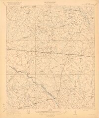
1920 Map of Limerick
USGS Topo · Published 1928About this map
Low-lying coastal plains and the dense riverine network of the Georgia coast define this 1920s survey. The landscape is dominated by the Cannochee River and Ogeechee River to the north, flowing toward the Medway R. and the tidal reaches of Dutchman Bay. Settlement patterns are heavily influenced by the intersecting paths of the Atlantic Coast Line and the Seaboard Air Line, which support a chain of small communities including Fleming, Limerick, and Belfast. Along the coast, the defensive position of Fort Morris stands near the historic settlement of Sunbury, overlooking the East Channel. Further inland, the presence of the H. & D. Lumber Co. R. R. near Riceboro indicates the importance of the timber industry to the local economy during this era, while landmarks like Midway Ch. and the Isle of Wight serve as established nodes of community life.
Find a feature on this map
43 named features on this map. Tap any name to fly to it.
Don’t see what you’re looking for? This feature index may not catch every label — zoom into the map to look around manually.
Map Details
Editions of this 1920 Limerick Map
This is the sole edition of this map. No revisions or reprints were ever made.
Other maps of this area

1918 · Hinesville
USGS Topo · 1:62,500
1920 · Pembroke
USGS Topo · 1:62,500

1920 · Meldrim
USGS Topo · 1:62,500

1920 · Sapelo River
USGS Topo · 1:62,500

1928 · St Catherines Island
USGS Topo · 1:62,500
1942 · Meldrim
USGS Topo · 1:62,500

1942 · Savannah
USGS Topo · 1:62,500
1943 · Ludowici
USGS Topo · 1:62,500
1943 · St Catherines Island
USGS Topo · 1:62,500

1943 · Sapelo River
USGS Topo · 1:62,500