1900s (20th Century) Maps of Wilmington, Georgia
Explore 10 historic maps of Wilmington from the 1900s (20th Century). These maps offer a rare glimpse into what life looked like during the 1900s — showing old roads, neighborhoods, homes, and landmarks that have changed or disappeared over time.
Whether you're researching your family's past, planning a metal detecting trip, or studying how Wilmington's landscape evolved across the 1900s, these high-resolution maps are a powerful tool for exploring the history of this region.
- Focus on a specific era: All maps on this page are from the 1900s, giving you a focused view of this time period.
- See what’s changed: Compare century-old streets, trails, and buildings to today's modern landscape using overlays and satellite layers.
- Research with precision: Use these maps for genealogy, historical research, land use analysis, or educational projects.
- View, download, or print: Maps are fully viewable online in high resolution, and can be downloaded or printed for your own records.
Start exploring Wilmington's history through authentic maps from the 1900s. This is your window into the past.
Wilmington, GA maps
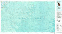
(10)- 1920 Map of Wassaw Sound
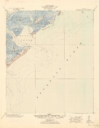 1920 Wassaw Sound1920 Print · USGSCoastal Georgia at the end of the Great War era reveals a landscape of tidal marshes and strategic barrier islands. Researchers can trace historic landmarks like the Great Wassaw Old Battery, the Cup of Hotel, and the winding Wilmington River.
 - 1945 Map of Wassaw Sound
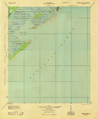 1945 Wassaw Sound1945 Print · USGSThe Georgia coast near Savannah comes alive in this mid-century survey of the barrier islands and tidal sounds. Genealogists and historians can trace the early layout of Savannah Beach or the pristine reaches of Wassaw Island and Petit Chou Island.
 - 1946 Map of Brunswick, 1948 Print
 1946 Brunswick1948 Print · USGSCoastal Georgia in the mid-forties reveals a landscape defined by the Camp Stewart Military Reservation and the sprawling barrier islands. Genealogists and historians can trace the rail-and-river network through inland towns like Ludowici and Jesup, or locate coastal landmarks like the St Simon Light.
 - 1948 Map of Brunswick
 1948 Brunswick1948 Print · USGSCoastal Georgia in the late 1940s is defined here by its labyrinthine barrier islands and the massive footprint of Camp Stewart. Genealogists and historians can trace the rail-tied growth of Jesup and Hinesville or locate coastal landmarks like St Simon Light.
 - 1956 Map of Brunswick, 1968 Print
 1956 Brunswick1968 Print · USGSThe Georgia coast in the mid-twentieth century is a wild expanse of barrier islands and massive river deltas. You can trace the development of the maritime economy and military presence at Brunswick, or locate historic sites like Fort Frederica National Monument and Harris Neck National Wildlife Refuge.2 unique versions available
 - 1957 Map of Wassaw Sound, 1959 Print
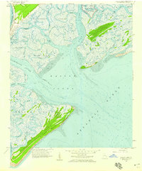 1957 Wassaw Sound1959 Print · USGSChatham County's coastal reaches were a wilderness of salt marshes and tidal rivers in the late fifties. Researchers can trace the secluded waterways of Wassaw Island or locate the historic grounds of Fort Pulaski National Monument.3 unique versions available
 - 1961 Map of Brunswick
 1961 Brunswick1961 Print · USGSThe Georgia coast at the start of the 1960s was a landscape of deep tidal marshes and growing military installations. Genealogists and historians can trace rail-linked towns like Limerick Station or explore coastal landmarks from Fort Frederica National Monument to Sapelo Island.
 - 1978 Map of Wassaw Sound
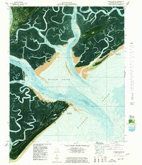 1978 Wassaw Sound1978 Print · USGSThe Georgia coast in the late seventies is revealed through this hybrid aerial and topographic study of the marshes and barrier islands. Researchers can trace the tidal reaches of the Wilmington River or locate landmarks like Dead Man Hammock and Fort Pulaski National Monument.
 - 1978 Map of Brunswick
 1978 Brunswick1978 Print · USGSThe Georgia coast and its barrier islands are captured in the late 1970s, as I-95 and the rail lines shaped the growth of coastal towns. Genealogists and historians can trace family locations across the islands or locate sites near Fort Stewart, Darien, and Ludowici.2 unique versions available
 - 1980 Map of Wassaw Sound, 1983 Print
 1980 Wassaw Sound1983 Print · USGSThe Georgia coast in the early eighties reveals a fascinating mix of strategic fortifications and preserved barrier islands. Trace the marshes around Wilmington Island or locate the grounds of Fort Pulaski National Monument and the Wassaw National Wildlife Refuge.2 unique versions available
End of results
Showing maps 1-10 of 10
Top cities near Wilmington
- Savannah historical maps
- Hilton Head Island historical maps
- Pooler historical maps
- Wilmington Island historical maps
- Garden City historical maps
- Port Wentworth historical maps
See more
Frequently asked questions
- What are the different types of historical maps available for Wilmington?
- What is the oldest map of Wilmington?
- Where can I purchase historical maps of Wilmington for my home or office?
- Where can I download high-res historical maps of Wilmington?
- Are there historical topographic maps available for Wilmington?
- Is there historical aerial imagery available for Wilmington?
- Where are historical maps of Wilmington sourced from?