1940s Maps of Cloudland, Georgia
Explore 2 historic maps of Cloudland from the 1940s. These maps offer a rare glimpse into what life looked like during the 1940s — showing old roads, neighborhoods, homes, and landmarks that have changed or disappeared over time.
Whether you're researching your family's past, planning a metal detecting trip, or studying how Cloudland's landscape evolved across the 1940s, these high-resolution maps are a powerful tool for exploring the history of this region.
- Focus on a specific era: All maps on this page are from the 1940s, giving you a focused view of this time period.
- See what’s changed: Compare century-old streets, trails, and buildings to today's modern landscape using overlays and satellite layers.
- Research with precision: Use these maps for genealogy, historical research, land use analysis, or educational projects.
- View, download, or print: Maps are fully viewable online in high resolution, and can be downloaded or printed for your own records.
Start exploring Cloudland's history through authentic maps from the 1940s. This is your window into the past.
Cloudland, GA maps
(2)- 1946 Map of Dougherty Gap, 1964 Print
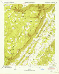 1946 Dougherty Gap1964 Print · USGSNorthwest Georgia in the mid-forties reveals a landscape shaped by the steep walls of Pigeon Mountain and the Tennessee Alabama and Georgia rail line. Genealogists can trace family footprints at Long Cem, Teloga Sch, and rural congregations like New Hope Ch.2 unique versions available
 - 1947 Map of Dougherty Gap
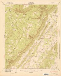 1947 Dougherty Gap1947 Print · USGSNorthwest Georgia in the late 1940s is defined here by the steep summits of Lookout Mountain and the remote communities of Chattooga County. Researchers can trace rural life through landmarks like Camp Juliette Low, the Macedonia Ch, and the route of the Tennessee Alabama and Georgia RR.2 unique versions available
End of results
Showing maps 1-2 of 2
Top cities near Cloudland
- Rome historical maps
- Fort Payne historical maps
- LaFayette historical maps
- Summerville historical maps
- Henagar historical maps
- Trion historical maps
See more
Frequently asked questions
- What are the different types of historical maps available for Cloudland?
- What is the oldest map of Cloudland?
- Where can I purchase historical maps of Cloudland for my home or office?
- Where can I download high-res historical maps of Cloudland?
- Are there historical topographic maps available for Cloudland?
- Is there historical aerial imagery available for Cloudland?
- Where are historical maps of Cloudland sourced from?