1990s Maps of Harmony, Georgia
Explore 1 historic maps of Harmony from the 1990s. These maps offer a rare glimpse into what life looked like during the 1990s — showing old roads, neighborhoods, homes, and landmarks that have changed or disappeared over time.
Whether you're researching your family's past, planning a metal detecting trip, or studying how Harmony's landscape evolved across the 1990s, these high-resolution maps are a powerful tool for exploring the history of this region.
- Focus on a specific era: All maps on this page are from the 1990s, giving you a focused view of this time period.
- See what’s changed: Compare century-old streets, trails, and buildings to today's modern landscape using overlays and satellite layers.
- Research with precision: Use these maps for genealogy, historical research, land use analysis, or educational projects.
- View, download, or print: Maps are fully viewable online in high resolution, and can be downloaded or printed for your own records.
Start exploring Harmony's history through authentic maps from the 1990s. This is your window into the past.
Harmony, GA maps
(1)- 1992 Map of Canton, 1993 Print
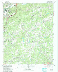 1992 Canton1993 Print · USGSCherokee County enters a period of modern growth in the early nineties, centered on the Etowah River and the expanding town of Canton. Researchers can trace family sites at St Paul Cem, find old rural hubs like Hickory Flat, or locate landmarks such as the Dean Rusk Sch and Askew County Park.
End of results
Showing maps 1-1 of 1
Top cities near Harmony
- Roswell historical maps
- Johns Creek historical maps
- Alpharetta historical maps
- Milton historical maps
- Kennesaw historical maps
- Woodstock historical maps
See more
Frequently asked questions
- What are the different types of historical maps available for Harmony?
- What is the oldest map of Harmony?
- Where can I purchase historical maps of Harmony for my home or office?
- Where can I download high-res historical maps of Harmony?
- Are there historical topographic maps available for Harmony?
- Is there historical aerial imagery available for Harmony?
- Where are historical maps of Harmony sourced from?