1900s (20th Century) Maps of Cobb County, Georgia
Explore 37 historic maps of Cobb County from the 1900s (20th Century). These maps offer a rare glimpse into what life looked like during the 1900s — showing old roads, neighborhoods, homes, and landmarks that have changed or disappeared over time.
Whether you're researching your family's past, planning a metal detecting trip, or studying how Cobb County's landscape evolved across the 1900s, these high-resolution maps are a powerful tool for exploring the history of this region.
- Focus on a specific era: All maps on this page are from the 1900s, giving you a focused view of this time period.
- See what’s changed: Compare century-old streets, trails, and buildings to today's modern landscape using overlays and satellite layers.
- Research with precision: Use these maps for genealogy, historical research, land use analysis, or educational projects.
- View, download, or print: Maps are fully viewable online in high resolution, and can be downloaded or printed for your own records.
Start exploring Cobb County's history through authentic maps from the 1900s. This is your window into the past.
Cobb County, GA maps
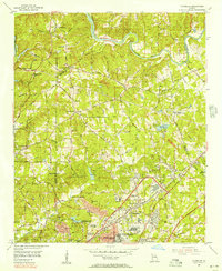
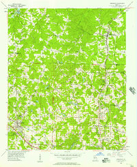
(37)- 1901 Map of Marietta
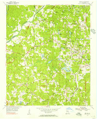
 1901 Marietta1901 Print · USGSNorthwest Georgia at the turn of the century is a landscape of growing rail towns and vital river crossings. Researchers can trace early rural life through features like Old Villarica, Pumpkintown Ferry, and the Mount Zion Church.4 unique versions available
 - 1907 Map of Acworth, 1954 Print
 1907 Acworth1954 Print · USGSNorthern Georgia's river-and-rail corridor is captured here at the start of the twentieth century. Genealogists can trace family roots near Acworth and Kennesaw or locate old crossings like Island Mills Ferry and Steels Bridge.
 - 1909 Map of Acworth
 1909 Acworth1909 Print · USGSNorth Georgia at the turn of the century shows a landscape of river ferries and emerging rail towns before the creation of modern reservoirs. Genealogists can trace family footprints near Acworth and Woodstock, or locate historic crossings like Island Mills Ferry and Steels Bridge.
 - 1953 Map of Atlanta, 1965 Print
 1953 Atlanta1965 Print · USGSThe growing Atlanta metro and the industrial corridors of Eastern Alabama are captured here during the mid-century transition. Researchers can trace the rail-to-road shift through hubs like Anniston and La Grange or locate sites within Fort McClellan.2 unique versions available
 - 1954 Map of Chamblee, 1956 Print
 1954 Chamblee1956 Print · USGSDeKalb and Fulton counties are caught in a moment of rapid post-war growth during the mid-fifties, just as the expressway begins to reshape the landscape. Researchers can trace the footprints of the U S Naval Reservation Atlanta Air Station, Oglethorpe Univ, and old family landmarks like Winters Chapel Cem.5 unique versions available
 - 1954 Map of Mableton, 1956 Print
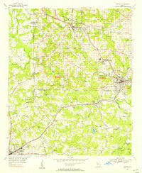
 1954 Mableton1956 Print · USGSNorthwest of Atlanta in the mid-fifties, this area shows a landscape transitioning between its rural roots and suburban growth. Researchers can trace family history through sites like Mable Cemetery or locate early industrial landmarks such as Orange Hill Mill and Cobb Airfield.5 unique versions available
 - 1954 Map of Lost Mountain, 1956 Print
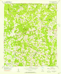 1954 Lost Mountain1956 Print · USGSCobb County's rural landscape is captured in the mid-1950s, showing a network of country churches and family-named roads before suburban expansion. Genealogists can locate family sites near John McEachern Sch, Corner Ch, and Red Rock.4 unique versions available
 - 1954 Map of Austell, 1956 Print
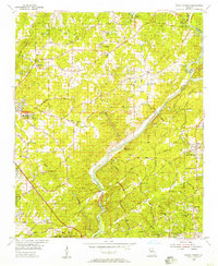
 1954 Austell1956 Print · USGSCobb and Douglas Counties are shown here during the mid-fifties, captured just as the industrial rail network and rural school districts were at their peak. Researchers can locate family landmarks like Smith Chapel and Pleasant Hill Ch or trace the early paths of the Seaboard Air Line.5 unique versions available
 - 1954 Map of Ben Hill, 1956 Print
 1954 Ben Hill1956 Print · USGSFulton County south of the river is caught in transition during the mid-fifties, balancing historic rural churches with the approaching reach of Atlanta. Researchers can locate family landmarks like the Mt Gilead Campground, Sandtown Sch, and the Atlantic Coast Line railroad.6 unique versions available
 - 1954 Map of Marietta, 1957 Print
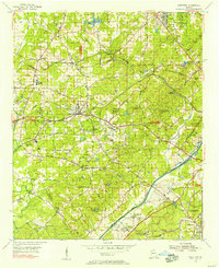
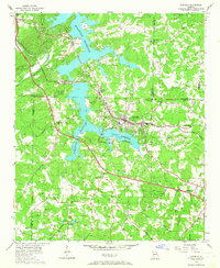
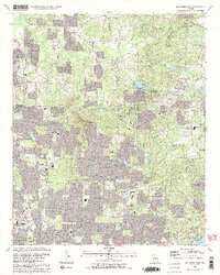
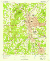 1954 Marietta1957 Print · USGSCobb County's post-war transition is on full display in the mid-fifties as Marietta expands and the military arrives. Trace family roots and local history near Kennesaw Mountain, Dobbins Air Force Base, and Blackwells.6 unique versions available
 - 1954 Map of Bolton, 1957 Print
 1954 Bolton1957 Print · USGSNorthwest Georgia in the mid-fifties reveals the dense intersection of industrial rail lines and established neighborhoods at the edge of the capital. Researchers can trace historic family plots and campus footprints at Crestlawn Cemetery, Georgia Institute of Technology, and Vinings.7 unique versions available
 - 1955 Map of Rome
 1955 Rome1955 Print · USGSThe tri-state borderlands of Georgia, Alabama, and Tennessee appear in the mid-fifties as a landscape of ridge-and-valley industry and river navigation. Genealogists can trace family footprints near Chattanooga, the iron works of Gadsden, and textile towns like Trion or Summerville.
 - 1955 Map of Sandy Springs, 1957 Print
 1955 Sandy Springs1957 Print · USGSThe northern edge of Atlanta and the banks of the Chattahoochee meet during a period of suburban transformation in the mid-fifties. Genealogists and local historians can trace family land via Heards Cem or locate community centers like the Powers Ferry Road Sch and Sardis Ch.6 unique versions available
 - 1956 Map of Kennesaw, 1957 Print
 1956 Kennesaw1957 Print · USGSCobb and Cherokee counties are captured in the mid-1950s during a period of steady growth along the Louisville and Nashville rail line. Researchers can trace old property boundaries across the 20th District and locate local landmarks like Wooten Lake, Bascomb, and Chastains Lakes.5 unique versions available
 - 1956 Map of Mountain Park, 1957 Print
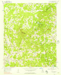 1956 Mountain Park1957 Print · USGSNorth Georgia in the mid-fifties remains a world of country churches and winding rural roads across the Cobb and Cherokee county lines. Trace family history through landmarks like Wesley Chapel, the Mountain View Sch, and the old crossing at Arnold Mill.6 unique versions available
 - 1956 Map of Acworth, 1957 Print
 1956 Acworth1957 Print · USGSAcworth and the surrounding Cobb County hills are shown here in the mid-1950s as the reservoir changed the landscape. Trace early roads and community centers like Mars Hill Ch, the Drive-in Theater, and the Nashville Chattanooga and St Louis line.6 unique versions available
 - 1957 Map of Atlanta
 1957 Atlanta1957 Print · USGSAtlanta and the Alabama borderlands appear here in the mid-fifties, capturing the region's post-war suburban and industrial transition. Trace the development of early transport hubs and military sites like Fort McPherson, Anniston, and the Kennesaw Mountain National Battlefield Park.
 - 1958 Map of Atlanta
 1958 Atlanta1958 Print · USGSMid-century Georgia and Alabama are shown in this regional study of the corridor between the Chattahoochee River and the Appalachian foothills. Local historians can trace the development of suburban Atlanta alongside vital landmarks like Stone Mountain, Dobbins AFB, and the Seaboard Air Line rail routes.
 - 1958 Map of Rome, 1966 Print
 1958 Rome1966 Print · USGSNorthwest Georgia and neighboring Tennessee and Alabama are captured here in the late fifties, showcasing a landscape of high ridges and river valleys. Researchers can trace historic rail lines like the Seaboard Air Line RR and explore the bounds of Cloudland Canyon State Park or Fort Oglethorpe.3 unique versions available
 - 1961 Map of Rome
 1961 Rome1961 Print · USGSNorthwest Georgia and neighboring Tennessee and Alabama are shown here at a moment of significant mid-century growth. Researchers can trace the rail networks of the Central of Georgia or locate landmarks within Chickamauga and Chattanooga Nat Military Park.
 - 1963 Map of Rome
 1963 Rome1963 Print · USGSThe tri-state corner of Georgia, Alabama, and Tennessee is captured here during a period of massive reservoir expansion and post-war growth. Genealogists and historians can trace the rail corridors of the Southern Ry or locate landmarks like Fort Oglethorpe and Cloudland Canyon State Park.
 - 1981 Map of Cartersville, 1982 Print
 1981 Cartersville1982 Print · USGSNorth Georgia at the start of the eighties shows a landscape defined by massive reservoirs and historic rail corridors. Researchers can trace the heritage of the Etowah Indian Mounds or locate old junctions along the Southern Railway and Seaboard Coast Line.2 unique versions available
 - 1981 Map of Atlanta, 1982 Print
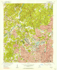
 1981 Atlanta1982 Print · USGSThe Atlanta metro area is shown during its late-century boom, following the completion of the beltway and the rise of its major international airport. Trace the growth of suburbs from Mableton to Tucker and the footprints of Fort McPherson and Stone Mtn.
 - 1992 Map of Marietta
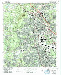 1992 Marietta1992 Print · USGSMarietta and Smyrna are shown during a period of rapid suburban growth in the early nineties, framed by significant military and civil war landmarks. Researchers can trace the sprawling grounds of Dobbins Air Force Base or locate local history at the Confederate Cem and Blackwells.2 unique versions available
 - 1992 Map of Mountain Park
 1992 Mountain Park1992 Print · USGSCobb and Cherokee Counties are seen during a period of rapid suburban growth in the early nineties. Genealogists can trace family names and local landmarks through Arnold Mill, Crossroad Church, and the Arnold Cem near the Fulton County line.2 unique versions available
Showing maps 1-25 of 37
Top cities of Cobb County
- Marietta historical maps
- Smyrna historical maps
- Mableton historical maps
- Kennesaw historical maps
- Acworth historical maps
- Powder Springs historical maps
See more
Frequently asked questions
- What are the different types of historical maps available for Cobb County?
- What is the oldest map of Cobb County?
- Where can I purchase historical maps of Cobb County for my home or office?
- Where can I download high-res historical maps of Cobb County?
- Are there historical topographic maps available for Cobb County?
- Is there historical aerial imagery available for Cobb County?
- Where are historical maps of Cobb County sourced from?