1960s Maps of Martinez, Georgia
Explore 3 historic maps of Martinez from the 1960s. These maps offer a rare glimpse into what life looked like during the 1960s — showing old roads, neighborhoods, homes, and landmarks that have changed or disappeared over time.
Whether you're researching your family's past, planning a metal detecting trip, or studying how Martinez's landscape evolved across the 1960s, these high-resolution maps are a powerful tool for exploring the history of this region.
- Focus on a specific era: All maps on this page are from the 1960s, giving you a focused view of this time period.
- See what’s changed: Compare century-old streets, trails, and buildings to today's modern landscape using overlays and satellite layers.
- Research with precision: Use these maps for genealogy, historical research, land use analysis, or educational projects.
- View, download, or print: Maps are fully viewable online in high resolution, and can be downloaded or printed for your own records.
Start exploring Martinez's history through authentic maps from the 1960s. This is your window into the past.
Martinez, GA maps
(3)- 1963 Map of Athens
 1963 Athens1963 Print · USGSGeorgia's Piedmont and the Savannah River valley are captured in the early sixties as major reservoirs and military installations reshaped the landscape. Researchers can trace the development of Clark Hill Reservoir, locate the Fort Gordon Military Reservation, and find historic towns like Social Circle and Eatonton.
 - 1964 Map of Martinez, 1966 Print
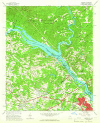 1964 Martinez1966 Print · USGSThe Savannah River borderlands in the mid-1960s reveal a mix of hydroelectric engineering and growing Georgia suburbs. Genealogists and historians can trace family sites at Abilene Ch, Martinez Sch, and the riverside Augusta City Lock and Dam.4 unique versions available
 - 1964 Map of Evans, 1966 Print
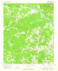 1964 Evans1966 Print · USGSColumbia County and the South Carolina borderlands are captured in the mid-1960s, showing a landscape of river islands and rural crossroad communities. Genealogists can locate family landmarks like Snellings Memorial Acre, Ropers Crossroads, and the remote Second Mt Carmel Ch.3 unique versions available
End of results
Showing maps 1-3 of 3
Top cities near Martinez
- Augusta historical maps
- North Augusta historical maps
- Grovetown historical maps
- Hephzibah historical maps
- Harlem historical maps
- Appling historical maps
Top neighborhoods of Martinez
- Memory Park historical maps
- Petersburg Station historical maps
- Phillips Estates historical maps
- Shenandoah historical maps
- Bonaire Heights historical maps
- Briarwood historical maps
See more
Frequently asked questions
- What are the different types of historical maps available for Martinez?
- What is the oldest map of Martinez?
- Where can I purchase historical maps of Martinez for my home or office?
- Where can I download high-res historical maps of Martinez?
- Are there historical topographic maps available for Martinez?
- Is there historical aerial imagery available for Martinez?
- Where are historical maps of Martinez sourced from?