1970s Maps of Cordele, Georgia
Explore 3 historic maps of Cordele from the 1970s. These maps offer a rare glimpse into what life looked like during the 1970s — showing old roads, neighborhoods, homes, and landmarks that have changed or disappeared over time.
Whether you're researching your family's past, planning a metal detecting trip, or studying how Cordele's landscape evolved across the 1970s, these high-resolution maps are a powerful tool for exploring the history of this region.
- Focus on a specific era: All maps on this page are from the 1970s, giving you a focused view of this time period.
- See what’s changed: Compare century-old streets, trails, and buildings to today's modern landscape using overlays and satellite layers.
- Research with precision: Use these maps for genealogy, historical research, land use analysis, or educational projects.
- View, download, or print: Maps are fully viewable online in high resolution, and can be downloaded or printed for your own records.
Start exploring Cordele's history through authentic maps from the 1970s. This is your window into the past.
Cordele, GA maps
(3)- 1974 Map of Cordele, 1988 Print
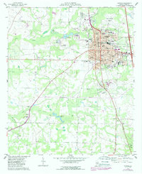 1974 Cordele1988 Print · USGSCordele and the surrounding Crisp County countryside are captured here during a period of steady growth in the mid-seventies. Researchers can trace family history at Sunnyside Cem or locate rural landmarks like Raines and the Cordele Fish Hatchery.
 - 1977 Map of Cordele
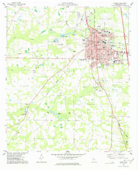 1977 Cordele1977 Print · USGSCordele thrived as a bustling South Georgia rail junction in the late seventies, where three major railroads converged. Genealogists and local historians can trace rural family sites like Macedonia Ch or locate the old County Prison Farm and Byrds Millpond.
 - 1977 Map of Penia
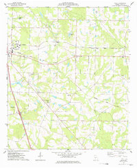 1977 Penia1977 Print · USGSCrisp County in the late seventies showcases a classic Georgia rail-and-farm landscape along the SEABOARD COAST LINE. Genealogists and local researchers can trace family connections through numerous rural landmarks like Dorough Cem, Zion Hope Ch, and Musselwhite.
End of results
Showing maps 1-3 of 3
Top cities near Cordele
- Ashburn historical maps
- Vienna historical maps
- Arabi historical maps
- Warwick historical maps
- Pitts historical maps
- Lilly historical maps
Frequently asked questions
- What are the different types of historical maps available for Cordele?
- What is the oldest map of Cordele?
- Where can I purchase historical maps of Cordele for my home or office?
- Where can I download high-res historical maps of Cordele?
- Are there historical topographic maps available for Cordele?
- Is there historical aerial imagery available for Cordele?
- Where are historical maps of Cordele sourced from?