1970s Maps of Decatur County, Georgia
Explore 11 historic maps of Decatur County from the 1970s. These maps offer a rare glimpse into what life looked like during the 1970s — showing old roads, neighborhoods, homes, and landmarks that have changed or disappeared over time.
Whether you're researching your family's past, planning a metal detecting trip, or studying how Decatur County's landscape evolved across the 1970s, these high-resolution maps are a powerful tool for exploring the history of this region.
- Focus on a specific era: All maps on this page are from the 1970s, giving you a focused view of this time period.
- See what’s changed: Compare century-old streets, trails, and buildings to today's modern landscape using overlays and satellite layers.
- Research with precision: Use these maps for genealogy, historical research, land use analysis, or educational projects.
- View, download, or print: Maps are fully viewable online in high resolution, and can be downloaded or printed for your own records.
Start exploring Decatur County's history through authentic maps from the 1970s. This is your window into the past.
Decatur County, GA maps
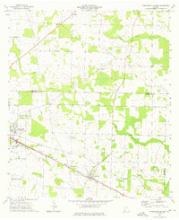
(11)- 1971 Map of Vada, 1974 Print
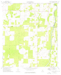
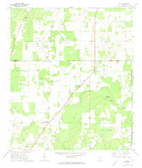 1971 Vada1974 Print · USGSDecatur and Mitchell counties are captured here in the early seventies, showing a rural landscape defined by karst sinks and small farming communities. Researchers can trace family sites at Salem Cem, Vada, and numerous country churches like Oak Grove Ch.2 unique versions available
 - 1974 Map of Boykin, 1976 Print
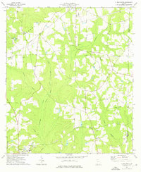
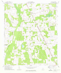 1974 Boykin1976 Print · USGSThe rural expanse of Miller and Decatur counties is captured here in the mid-seventies, showing the rail-side growth of communities like Boykin and Eldorendo. Genealogists can locate family landmarks including Lane Cem, Evergreen Ch, and Pilgrims Rest Ch.
 - 1974 Map of Bainbridge, 1976 Print
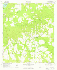
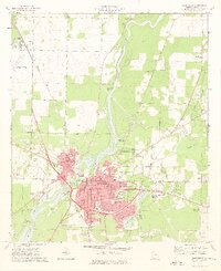 1974 Bainbridge1976 Print · USGSBainbridge sits at a technological and industrial crossroads in the mid-seventies, dominated by the Flint River and the Seaboard Coast Line. Researchers can locate numerous neighborhood landmarks like the Hutto Jr High Sch, Oak City Cem, and Mt Zion Ch.2 unique versions available
 - 1974 Map of Faceville, 1976 Print
 1974 Faceville1976 Print · USGSDecatur County, Georgia, is shown here in the mid-seventies, where the Flint River waters spread across the landscape. Genealogists and historians can trace the rural communities of Bethany and Faceville, or locate family landmarks like Breedlove Cem and Salem Ch.
 - 1974 Map of Donalsonville East, 1976 Print
 1974 Donalsonville East1976 Print · USGSSeminole County was a landscape of quiet agricultural hamlets and rail-side settlements in the mid-seventies. Genealogists can trace family landmarks like Friendship Cem and Miller Cems, or locate rural congregations at Corinth Ch and New Home Ch.
 - 1974 Map of Fowlstown, 1976 Print
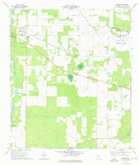
 1974 Fowlstown1976 Print · USGSDecatur County in the mid-1970s is captured here at the intersection of the Seaboard Coast Line and the Flint River. Genealogists can trace several community hubs like Fowlstown and find rural landmarks such as Mt Nebo Ch Cem and Emanuel Ch.
 - 1974 Map of Brinson, 1976 Print
 1974 Brinson1976 Print · USGSSouth Georgia's agricultural and institutional landscape comes to life in this mid-seventies survey of western Decatur County. Genealogists and researchers can trace local landmarks like Bainbridge State Hospital, Yates Springs, and the Jackson Cem.
 - 1974 Map of Climax North, 1976 Print
 1974 Climax North1976 Print · USGSThe rural landscape of Decatur County in the mid-1970s reveals a community centered on the rail junction at Climax. Genealogists and local historians can trace rural family roots through numerous sites like Fleatown Cem, Travelers Rest Ch, and Parker Courthouse.
 - 1974 Map of Steinham Store, 1976 Print
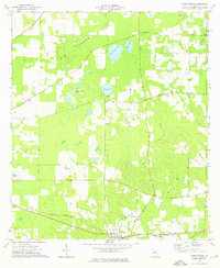
 1974 Steinham Store1976 Print · USGSThe rural Georgia backcountry in the mid-seventies is defined here by the winding Flint River and a network of quiet country crossroads. Genealogists can trace family connections to several local congregations like First Macedonia Ch and the landmark Steinham Store.
 - 1974 Map of Climax South, 1976 Print
 1974 Climax South1976 Print · USGSDecatur County during the mid-seventies shows a landscape of established rural settlements and rail-line communities. Researchers can trace family history through numerous rural landmarks like Samuel Cem, Antioch Ch, and the town of Attapulgus.
 - 1978 Map of Bainbridge, 1980 Print
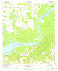
 1978 Bainbridge1980 Print · USGSIn the late seventies, this Georgia-Florida borderland was defined by the confluence of the Flint and Chattahoochee rivers. Trace the region's infrastructure via the Seaboard Coast Line Railroad and find sites like Bainbridge State Hospital.
End of results
Showing maps 1-11 of 11
Top cities of Decatur County
Frequently asked questions
- What are the different types of historical maps available for Decatur County?
- What is the oldest map of Decatur County?
- Where can I purchase historical maps of Decatur County for my home or office?
- Where can I download high-res historical maps of Decatur County?
- Are there historical topographic maps available for Decatur County?
- Is there historical aerial imagery available for Decatur County?
- Where are historical maps of Decatur County sourced from?