
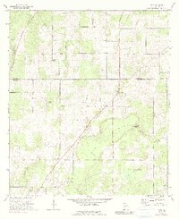
1971 Map of Vada
USGS Topo · Published 1974About this map
Agricultural lands and isolated pine stands define this southwest Georgia landscape where Mitchell and Decatur counties meet. The small settlement of Vada serves as a local hub near the northern edge of the map, while Mt Pleasant sits further south along the highway corridor. The terrain is notably marked by the karst topography of the Dougherty Plain, featuring significant depressions like Little Rock Sink and Big Rock Sink.
Find a feature on this map
21 named features on this map. Tap any name to fly to it.
Don’t see what you’re looking for? This feature index may not catch every label — zoom into the map to look around manually.
Map Details
Editions of this 1971 Vada Map
2 editions found
Other maps of this area

1953 · Dothan
USGS Topo · 1:250,000

1954 · Dothan
USGS Topo · 1:250,000

1954 · Tallahassee
USGS Topo · 1:250,000

1955 · Dothan
USGS Topo · 1:250,000

1955 · Bainbridge
USGS Topo · 1:62,500

1955 · Whigham
USGS Topo · 1:62,500

1959 · Tallahassee
USGS Topo · 1:250,000

1960 · Tallahassee
USGS Topo · 1:250,000

1971 · Gee Pond
USGS Topo · 1:24,000

1971 · Hopeful
USGS Topo · 1:24,000