1970s Maps of Springfield, Georgia
Explore 2 historic maps of Springfield from the 1970s. These maps offer a rare glimpse into what life looked like during the 1970s — showing old roads, neighborhoods, homes, and landmarks that have changed or disappeared over time.
Whether you're researching your family's past, planning a metal detecting trip, or studying how Springfield's landscape evolved across the 1970s, these high-resolution maps are a powerful tool for exploring the history of this region.
- Focus on a specific era: All maps on this page are from the 1970s, giving you a focused view of this time period.
- See what’s changed: Compare century-old streets, trails, and buildings to today's modern landscape using overlays and satellite layers.
- Research with precision: Use these maps for genealogy, historical research, land use analysis, or educational projects.
- View, download, or print: Maps are fully viewable online in high resolution, and can be downloaded or printed for your own records.
Start exploring Springfield's history through authentic maps from the 1970s. This is your window into the past.
Springfield, GA maps
(2)- 1978 Map of Springfield North
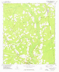 1978 Springfield North1978 Print · USGSEffingham County during the late seventies is captured here at the intersection of rural life and regional rail networks. Genealogists and local historians can trace family locations near Clyo, Kieffer Cem, and several country churches like Turkey Branch Ch.
 - 1978 Map of Springfield South
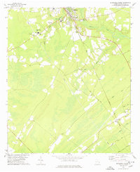 1978 Springfield South1978 Print · USGSEffingham County in the late seventies reveals a landscape of growing towns and established rail corridors. Genealogists can locate family landmarks such as Effingham Academy, Goodwill Ch, and several rural Cem sites tucked along Ebenezer Creek.
End of results
Showing maps 1-2 of 2
Top cities near Springfield
- Savannah historical maps
- Pooler historical maps
- Port Wentworth historical maps
- Rincon historical maps
- Hardeeville historical maps
- Bloomingdale historical maps
See more
Top neighborhoods of Springfield
Frequently asked questions
- What are the different types of historical maps available for Springfield?
- What is the oldest map of Springfield?
- Where can I purchase historical maps of Springfield for my home or office?
- Where can I download high-res historical maps of Springfield?
- Are there historical topographic maps available for Springfield?
- Is there historical aerial imagery available for Springfield?
- Where are historical maps of Springfield sourced from?