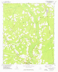
1978 Map of Springfield North
USGS Topo · Published 1978About this map
The town of Springfield serves as a southern anchor for this map of Effingham County, where the landscape is defined by the wetlands surrounding Ebenezer Creek and its many tributaries. The area's mid-century rural character is evidenced by numerous congregational landmarks such as Silver Hill Ch and Laurel Hill Ch, alongside several local family-named cemeteries. Two major rail corridors, the Seaboard Coast Line and the Central of Georgia, cut through the low-lying terrain, connecting small settlements like Clyo, Berryville, and Bethel. Significant drainage systems, including Cowpen Branch, Runs Branch, and Turkey Branch, snake through the pine and hardwood flats, illustrating the historical reliance on natural waterways for land demarcation. This 1970s survey captures a moment when the regional economy remained deeply tied to these transport lines and the timbered basins of the coastal plain.
Find a feature on this map
27 named features on this map. Tap any name to fly to it.
Don’t see what you’re looking for? This feature index may not catch every label — zoom into the map to look around manually.
Map Details
Editions of this 1978 Springfield North Map
This is the sole edition of this map. No revisions or reprints were ever made.
Other maps of this area

1919 · Pineland
USGS Topo · 1:62,500

1919 · Shirley
USGS Topo · 1:62,500

1919 · Egypt
USGS Topo · 1:62,500

1920 · Hardeeville
USGS Topo · 1:62,500

1939 · Egypt
USGS Topo · 1:62,500

1943 · Pineland
USGS Topo · 1:62,500

1943 · Hardeeville
USGS Topo · 1:62,500

1943 · Egypt
USGS Topo · 1:62,500

1943 · Shirley
USGS Topo · 1:62,500

1947 · Savannah
USGS Topo · 1:250,000