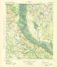
1943 Map of Shirley
USGS Topo · Published 1943About this map
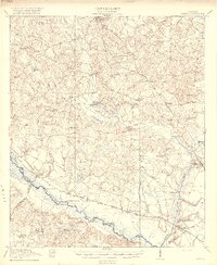
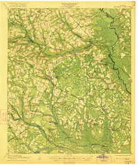
The Savannah River defines this landscape, forming a complex boundary between South Carolina and Georgia characterized by numerous landings and river bends. During the early 1940s, this corridor was a mix of swampy lowlands and upland agricultural settlements connected by the Seaboard Railroad and historic routes like the Augusta Road. The map reveals a dense network of local landmarks, including the uniquely named Heavenly Rest Ch and various country schools such as Mizpah Sch and Cypressvale Sch. The river itself is punctuated by named points and landings like Hudson Ferry Landing and Martins Landing, which served as critical transit points before modern bridge infrastructure dominated the region. These features, along with the Morrison Switch rail siding, indicate an economy still deeply tied to the movement of goods via water and rail.
Find a feature on this map
80 named features on this map. Tap any name to fly to it.
Don’t see what you’re looking for? This feature index may not catch every label — zoom into the map to look around manually.
Map Details
Editions of this 1943 Shirley Map
This is the sole edition of this map. No revisions or reprints were ever made.
Other maps of this area

1918 · Varnville
USGS Topo · 1:62,500
1918 · Oliver
USGS Topo · 1:62,500

1919 · Pineland
USGS Topo · 1:62,500
1919 · Shirley
USGS Topo · 1:62,500
1919 · Egypt
USGS Topo · 1:62,500

1920 · Hardeeville
USGS Topo · 1:62,500

1920 · Hilltonia
USGS Topo · 1:62,500
1920 · Oliver
USGS Topo · 1:62,500

1920 · Peeples
USGS Topo · 1:62,500
1921 · Brooklet
USGS Topo · 1:62,500