
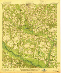
1920 Map of Oliver
USGS Topo · Published 1920About this map
The Ogeechee River and the Central of Georgia railroad corridor define the economic life of Screven County at the end of the Great War. This landscape is a dense network of river landings and rail stops, where agricultural commerce centered on places like Hendersons Landing, Cameron, and Opies Landing. The interior is characterized by a high concentration of community-building institutions, including Double Head Church, Lee Memorial Church, and numerous rural schools like Captolo School and Middle Ground School, which served the dispersed farming families of the era.
Find a feature on this map
55 named features on this map. Tap any name to fly to it.
Don’t see what you’re looking for? This feature index may not catch every label — zoom into the map to look around manually.
Map Details
Editions of this 1920 Oliver Map
2 editions found
Other maps of this area

1918 · Oliver
USGS Topo · 1:62,500

1919 · Shirley
USGS Topo · 1:62,500

1919 · Egypt
USGS Topo · 1:62,500

1920 · Statesboro
USGS Topo · 1:62,500

1920 · Hilltonia
USGS Topo · 1:62,500

1920 · Millen
USGS Topo · 1:62,500

1920 · Peeples
USGS Topo · 1:62,500

1921 · Brooklet
USGS Topo · 1:62,500

1921 · Rocky Ford
USGS Topo · 1:62,500

1939 · Egypt
USGS Topo · 1:62,500