
1919 Map of Egypt
USGS Topo · Published 1919About this map
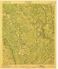
Springfield and the surrounding piney woods of Effingham County are captured here just after the Great War, revealing a landscape defined by its river landings and expanding railroad network. The Ogeechee River forms the western boundary, dotted with transit points like Taylor Landing and Alderman Landing, while the crossing at Cone Bridge links the area to Bulloch County. This era shows the height of the local rail economy, as lines like the Central of Georgia and the Savannah and Atlanta connect timber and agricultural hubs such as Guyton, Egypt, and Pineora. Interspersed between these rail towns are numerous community anchors, including Shiloh School and Corinth Church, marking the rural social centers of early 20th-century Georgia before the widespread adoption of modern highways.
Find a feature on this map
56 named features on this map. Tap any name to fly to it.
Don’t see what you’re looking for? This feature index may not catch every label — zoom into the map to look around manually.
Map Details
Editions of this 1919 Egypt Map
3 editions found
Other maps of this area

1918 · Oliver
USGS Topo · 1:62,500

1919 · Pineland
USGS Topo · 1:62,500

1919 · Shirley
USGS Topo · 1:62,500

1920 · Hardeeville
USGS Topo · 1:62,500

1920 · Pembroke
USGS Topo · 1:62,500

1920 · Meldrim
USGS Topo · 1:62,500

1920 · Oliver
USGS Topo · 1:62,500

1921 · Brooklet
USGS Topo · 1:62,500

1939 · Egypt
USGS Topo · 1:62,500

1942 · Meldrim
USGS Topo · 1:62,500