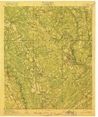
1919 Map of Egypt
USGS Topo · Published 1919About this map
Springfield and Guyton anchor this survey of Effingham County, Georgia, just after the First World War. The landscape is defined by the heavy presence of the Central Of Georgia and Savannah And Atlanta railroads, which facilitated the movement of timber and agricultural products through the coastal plain. The Ogeechee River forms the western boundary, its winding course marked by several family-named landings such as Alderman Landing and Taylor Landing. Small rural communities like Egypt, Marlow, and Pineora are scattered along the rail lines, each serving as local hubs for the surrounding farmsteads. The placement of Corinth Church, Bethel Church, and numerous rural schoolhouses including Morgan School and Dasher School reveals the social organization of the county's rural districts. Water features like Great Bay and Jack Creek highlight the low-lying, often swampy terrain that influenced the original layout of the Augusta and Savannah Road.
Find a feature on this map
52 named features on this map. Tap any name to fly to it.
Don’t see what you’re looking for? This feature index may not catch every label — zoom into the map to look around manually.
Map Details
Editions of this 1919 Egypt Map
3 editions found
Other maps of this area

1918 · Oliver
USGS Topo · 1:62,500

1919 · Pineland
USGS Topo · 1:62,500

1919 · Shirley
USGS Topo · 1:62,500

1919 · Egypt
USGS Topo · 1:62,500

1920 · Hardeeville
USGS Topo · 1:62,500

1920 · Pembroke
USGS Topo · 1:62,500

1920 · Meldrim
USGS Topo · 1:62,500

1920 · Oliver
USGS Topo · 1:62,500

1921 · Brooklet
USGS Topo · 1:62,500

1939 · Egypt
USGS Topo · 1:62,500