1910s Maps of Stillwell, Georgia
Explore 1 historic maps of Stillwell from the 1910s. These maps offer a rare glimpse into what life looked like during the 1910s — showing old roads, neighborhoods, homes, and landmarks that have changed or disappeared over time.
Whether you're researching your family's past, planning a metal detecting trip, or studying how Stillwell's landscape evolved across the 1910s, these high-resolution maps are a powerful tool for exploring the history of this region.
- Focus on a specific era: All maps on this page are from the 1910s, giving you a focused view of this time period.
- See what’s changed: Compare century-old streets, trails, and buildings to today's modern landscape using overlays and satellite layers.
- Research with precision: Use these maps for genealogy, historical research, land use analysis, or educational projects.
- View, download, or print: Maps are fully viewable online in high resolution, and can be downloaded or printed for your own records.
Start exploring Stillwell's history through authentic maps from the 1910s. This is your window into the past.
Stillwell, GA maps
(1)- 1919 Map of Egypt
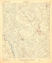 1919 Egypt1919 Print · USGSEffingham County during the late teens was a thriving network of river landings and competing railroad lines. Genealogists can trace family names at local landmarks like Dasher School, Bethel Church, and riverside hubs like Joe Cone Landing.3 unique versions available
End of results
Showing maps 1-1 of 1
Top cities near Stillwell
- Savannah historical maps
- Pooler historical maps
- Port Wentworth historical maps
- Rincon historical maps
- Hardeeville historical maps
- Bloomingdale historical maps
See more
Frequently asked questions
- What are the different types of historical maps available for Stillwell?
- What is the oldest map of Stillwell?
- Where can I purchase historical maps of Stillwell for my home or office?
- Where can I download high-res historical maps of Stillwell?
- Are there historical topographic maps available for Stillwell?
- Is there historical aerial imagery available for Stillwell?
- Where are historical maps of Stillwell sourced from?