Old Maps of Evans County, Georgia
Explore 73 old maps of Evans County, spanning from 1919 to today. These high-resolution historic maps reveal how streets, neighborhoods, landmarks, and natural features evolved over time — perfect for genealogy, metal detecting, research, and local history exploration.
What you can do with these maps:
- See how Evans County changed over time: Compare historical maps to modern-day views to trace roads, homesites, rail lines & more.
- View detailed metadata: Each map includes creators, publishers, year, scale, and archive source.
- Overlay maps with satellite & LiDAR: Visualize the past alongside modern tools to explore terrain & human change.
- Trusted historical sources: Maps sourced from the USGS, Library of Congress, and other archives.
- Access maps your way: View online, download high-res files, or order prints for personal or research use.
Start exploring old maps of Evans County to uncover forgotten places, hidden landmarks, and the deep history beneath your feet.
Evans County, GA maps
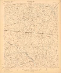
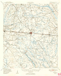
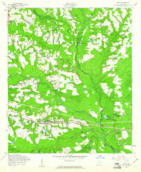
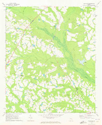
(73)- 1919 Map of Claxton
 1919 Claxton1919 Print · USGSSoutheast Georgia rail towns thrive along the Seaboard Air Line just after the Great War, showing a landscape shaped by timber and local agriculture. Genealogists can locate over twenty rural schools and crossings like Deans Crossing, Liberia School, and Hagan.3 unique versions available
 - 1920 Map of Pembroke
 1920 Pembroke1920 Print · USGSGeorgia's coastal plain emerges in the years after the Great War, showing a network of rail lines and river landings. Genealogists can trace old family roots through Stevens Grove School, Beulah Church, and the settlement at Pembroke.3 unique versions available
 - 1920 Map of Statesboro
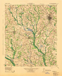
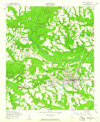
 1920 Statesboro1920 Print · USGSSoutheast Georgia was a bustling junction of regional railways just after the First World War. Researchers can trace family roots and land ownership across a network of rural schools like Smith Allen Deaf School, small settlements like Adabelle, and the prominent Central of Georgia Railway.4 unique versions available
 - 1943 Map of Statesboro
 1943 Statesboro1943 Print · USGSStatesboro and its rural Georgia surroundings appear in wartime detail, showing the busy Central of Georgia rail lines and early road networks. Genealogists can trace family connections to many local landmarks like Smith Allen Deal Sch and Langston Chapel.
 - 1944 Map of Claxton
 1944 Claxton1944 Print · USGSSoutheast Georgia was undergoing significant change in the 1940s as military expansion met established rail towns and rural school districts. Genealogists and historians can trace the footprint of Camp Stewart alongside family-named landmarks like Beasley Sch, Moodys Crossing, and Brewton Mill Sch.
 - 1947 Map of Savannah
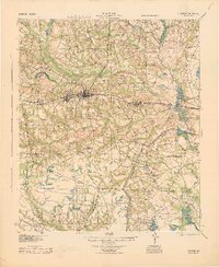
 1947 Savannah1947 Print · USGSCoastal Georgia and South Carolina are captured here in the mid-forties, showing the rail-and-river networks of the Lowcountry. Genealogists and researchers can trace old crossroads and river towns from Statesboro to Beaufort, alongside military sites like Camp Stewart and Parris Island.
 - 1948 Map of Savannah
 1948 Savannah1948 Print · USGSThe Georgia and South Carolina Lowcountry comes alive in this post-war survey of the coast and its river-fed hinterlands. Genealogists and historians can trace rail lines like the Central of Georgia RR and find established settlements such as Isle of Hope and Sylvania.
 - 1948 Map of Pembroke, 1966 Print
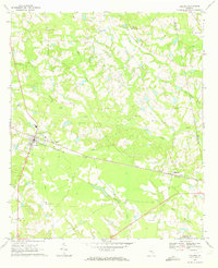
 1948 Pembroke1966 Print · USGSPembroke and the surrounding Georgia pine lands are captured here just after the war, showing a landscape defined by the railroad and the military. Genealogists can trace family names at Beautiful Zion Cem, Ash Branch Church, and several rural schools like Midway Sch.
 - 1950 Map of Pembroke
 1950 Pembroke1950 Print · USGSIn mid-century Bryan County, the landscape around Pembroke was a mix of vital rail lines and expanding military boundaries. Genealogists and local historians can trace family locations near Beautiful Zion Cem, Ash Branch Church, and the rural Esla Sch.2 unique versions available
 - 1950 Map of Claxton
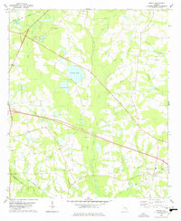
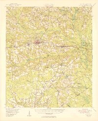 1950 Claxton1950 Print · USGSMid-century Evans County centers on the thriving rail corridor connecting Claxton, Hagan, and Daisy during the height of the Seaboard Air Line era. Genealogists and historians can locate numerous rural landmarks like the Ennis Branch School, Sikes Chapel, and the vast Camp Stewart Military Reservation.2 unique versions available
 - 1957 Map of Macon
 1957 Macon1957 Print · USGSMid-century Georgia comes into focus as the river-and-rail economy shifts toward a new era of aviation and highway travel. Trace family roots and vanished landmarks across the Ocmulgee River valley from Macon to the onion fields of Vidalia.
 - 1957 Map of Savannah, 1967 Print
 1957 Savannah1967 Print · USGSThe Lowcountry and Georgia coastal plain are shown here in the late fifties, prior to modern expansion. Researchers can trace the rail-and-river economy through the Central of Georgia lines and the Ogeechee River wetlands.4 unique versions available
 - 1958 Map of Macon
 1958 Macon1958 Print · USGSMiddle Georgia during the late fifties shows the post-war expansion of Warner Robins alongside the deep-rooted rail hubs of the Central of Georgia line. Researchers can trace the river-bound boundaries of numerous counties and find local landmarks like Veterans Memorial Hospital and Robins AFB.
 - 1958 Map of Deans Crossing, 1961 Print
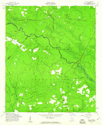
 1958 Deans Crossing1961 Print · USGSTattnall and Evans counties are captured in the late fifties during a period of rural transition along Beards Creek. Genealogists can trace family roots through numerous sites like Kennedy Cem, Midway Sch, and Tar City Ch.3 unique versions available
 - 1958 Map of Glissons Millpond, 1961 Print
 1958 Glissons Millpond1961 Print · USGSCoastal Georgia in the late fifties shows a rural landscape transitioning into the Fort Stewart Military Reservation. Researchers can locate family burial sites at Barnard Cem or trace the remnant of an Old Railroad Grade near Camp Oliver.3 unique versions available
 - 1958 Map of Daisy, 1961 Print
 1958 Daisy1961 Print · USGSThe rural landscape around Daisy and the Canoochee River is captured here in the late fifties, during a period when the railroad and local mills still shaped community life. Researchers can trace family history through sites like St Luke Ch, the De Loach Mill, and Rogers Cem.3 unique versions available
 - 1958 Map of Willie, 1961 Print
 1958 Willie1961 Print · USGSLiberty County was undergoing a major transformation in the late fifties as military expansion reshaped the rural landscape. Genealogists and historians can locate the former Willie settlement and trace ancestral roots at Jerusalem Cem or Salem Cem.3 unique versions available
 - 1958 Map of Claxton, 1961 Print
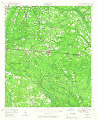
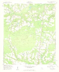
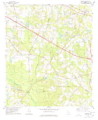
 1958 Claxton1961 Print · USGSEvans County in the late fifties shows the steady rhythm of a railroad and timber economy centered on Claxton and Hagan. Researchers can trace old family landmarks and community hubs, from Sikes Chapel and Brewton Cem to the local Drive-in Theater.2 unique versions available
 - 1960 Map of Savannah
 1960 Savannah1960 Print · USGSCoastal Georgia and the South Carolina Lowcountry are captured in the late fifties, showcasing the intricate web of islands and tidal rivers before modern expansion. Researchers can trace the rail lines of the Atlantic Coast Line or locate sites like Parris Island, Beaufort, and the Tybee Lighthouse.
 - 1961 Map of Savannah
 1961 Savannah1961 Print · USGSThe Georgia and South Carolina Lowcountry comes alive in this mid-century survey of coastal marshes, barrier islands, and river networks. Genealogists and historians can trace the paths of the Seaboard Air Line RR, locate family sites near Isle of Hope, or study the grounds of Fort Stewart Military Reservation.2 unique versions available
 - 1964 Map of Macon
 1964 Macon1964 Print · USGSCentral Georgia in the mid-sixties is defined by its major river valleys and a booming military presence. Genealogists and historians can trace the growth of Warner Robins near Robins AFB or locate smaller rural junctions like Allentown and Jeffersonville along the historic Southern railroad lines.2 unique versions available
 - 1970 Map of Collins, 1973 Print
 1970 Collins1973 Print · USGSThe Tattnall County countryside around Collins and Manassas appears here during the early 1970s, linked by the rail corridor. Genealogists and local historians can trace family roots through numerous sites like Old Tippins Cem and Rodgers Ch Cem.
 - 1970 Map of Metter SE, 1973 Print
 1970 Metter SE1973 Print · USGSCandler County in the early seventies is a landscape of winding river bottoms and rural congregations. Genealogists and local historians can trace the foundations of the community through landmarks like Primitive Grove Ch, Everitt Cem, and Metter Airport.2 unique versions available
 - 1978 Map of Nevils
 1978 Nevils1978 Print · USGSBulloch and Evans counties are shown in the late seventies as a landscape of agricultural fields and creek branches. Genealogists can trace family roots through numerous sites like Harmony Ch, Union Ch, and the Old Railroad Grade near Nevils.
 - 1978 Map of Register
 1978 Register1978 Print · USGSBulloch County during the late 1970s reveals a landscape of small crossroads settlements and river-bottom timberlands. Genealogists can locate family landmarks like Kennedy Bridge, St Pauls Ch, and rural communities such as Adabelle and New Hope.
Showing maps 1-25 of 73
Top cities of Evans County
Frequently asked questions
- What are the different types of historical maps available for Evans County?
- What is the oldest map of Evans County?
- Where can I purchase historical maps of Evans County for my home or office?
- Where can I download high-res historical maps of Evans County?
- Are there historical topographic maps available for Evans County?
- Is there historical aerial imagery available for Evans County?
- Where are historical maps of Evans County sourced from?