1930s Maps of Morganton, Georgia
Explore 4 historic maps of Morganton from the 1930s. These maps offer a rare glimpse into what life looked like during the 1930s — showing old roads, neighborhoods, homes, and landmarks that have changed or disappeared over time.
Whether you're researching your family's past, planning a metal detecting trip, or studying how Morganton's landscape evolved across the 1930s, these high-resolution maps are a powerful tool for exploring the history of this region.
- Focus on a specific era: All maps on this page are from the 1930s, giving you a focused view of this time period.
- See what’s changed: Compare century-old streets, trails, and buildings to today's modern landscape using overlays and satellite layers.
- Research with precision: Use these maps for genealogy, historical research, land use analysis, or educational projects.
- View, download, or print: Maps are fully viewable online in high resolution, and can be downloaded or printed for your own records.
Start exploring Morganton's history through authentic maps from the 1930s. This is your window into the past.
Morganton, GA maps
(4)- 1935 Map of Mineral Bluff
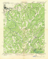 1935 Mineral Bluff1935 Print · USGSThe tri-state border region of Georgia, Tennessee, and North Carolina comes alive in the mid-1930s as industry and infrastructure reshape the mountain landscape. Genealogists can locate family landmarks like Paintertown Sch, Shady Grove Ch, and the homes near Mineral Bluff.
 - 1935 Map of Lake Toccoa
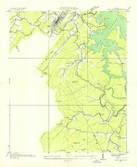 1935 Lake Toccoa1935 Print · USGSNorth Georgia’s mountain and river life is preserved here during the mid-1930s transition into the hydroelectric era. Researchers can trace family roots through the numerous rural schools and churches, such as Stanley Creek Sch, Union Ch, and landmarks like Stanley Mill.
 - 1935 Map of Wilscot
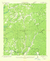 1935 Wilscot1935 Print · USGSNorth Georgia mountain life is caught in a moment of transition in the mid-1930s as the TVA and CCC arrived in the Blue Ridge. Genealogists can trace old homesteads and landmarks like Star Creek Mill, Sugar Hill Ch, and CCC Camp F 8 along the Toccoa River.
 - 1935 Map of Culberson
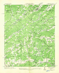 1935 Culberson1935 Print · USGSThe borderlands of North Carolina and Georgia come alive in this mid-1930s study of the mountain gaps and rail corridors. Genealogists and historians can trace family-named sites like Hawkins Mill, Bell Sch, and New Liberty Ch along the winding Hemptown Creek.
End of results
Showing maps 1-4 of 4
Top cities near Morganton
- Murphy historical maps
- McCaysville historical maps
- Blue Ridge historical maps
- East Ellijay historical maps
- Copperhill historical maps
- Ducktown historical maps
Frequently asked questions
- What are the different types of historical maps available for Morganton?
- What is the oldest map of Morganton?
- Where can I purchase historical maps of Morganton for my home or office?
- Where can I download high-res historical maps of Morganton?
- Are there historical topographic maps available for Morganton?
- Is there historical aerial imagery available for Morganton?
- Where are historical maps of Morganton sourced from?