Old Maps of Morganton, Georgia for Academic Research
Study the evolution of Morganton with 46 high-resolution historic maps. Whether you're teaching, researching, or modeling changes in land use, these maps provide essential visual documentation of urban, environmental, and geographic change.
- Analyze long-term change: Track patterns in development, transportation, and natural features.
- Ideal for environmental or urban studies: Support academic projects with primary historical map data.
- Use in the classroom or lab: Educators and researchers rely on these maps to bring historical context to life.
These maps are a powerful tool for teaching, research, and visualizing how Morganton has changed over the decades.
Morganton, GA maps
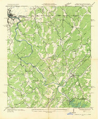
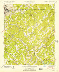
(46)- 1888 Map of Ellijay
 1888 Ellijay1888 Print · USGSNorth Georgia in the late 1880s was a land of high peaks and emerging rail lines as the mountains were first being methodically surveyed. You can trace the Marietta and North Georgia Railroad through Blue Ridge and locate vanished stops like Vanzants Store or the rural community of Cherry Log.
 - 1892 Map of Ellijay
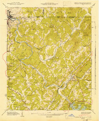
 1892 Ellijay1892 Print · USGSNorth Georgia's mountain communities were primarily connected by river valleys and the winding Marietta and North Georgia Railroad in the late nineteenth century. Genealogists can trace early homesteads and centers of trade like Vanzant's Store, Mineral Bluff, and Cherry Log.
 - 1898 Map of Ellijay
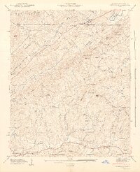
 1898 Ellijay1898 Print · USGSNorth Georgia’s mountain country is captured here in the late nineteenth century, showing the early development of Gilmer and Fannin counties. Genealogists can trace family homesteads near old river crossings like Centers Ferry and settlements such as Mineral Bluff and Whitepath.2 unique versions available
 - 1911 Map of Ellijay
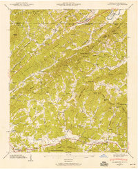
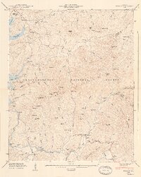
 1911 Ellijay1911 Print · USGSNorth Georgia and the Tennessee border are captured here at the turn of the century, showing a mountain landscape of river ferries and early rail. Genealogists can locate family landmarks like Higdons Store, the Pisgah church, or crossings at Bakers Ferry and Shallow Ford.4 unique versions available
 - 1935 Map of Mineral Bluff
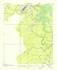
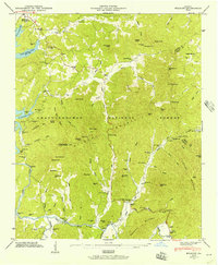
 1935 Mineral Bluff1935 Print · USGSThe tri-state border region of Georgia, Tennessee, and North Carolina comes alive in the mid-1930s as industry and infrastructure reshape the mountain landscape. Genealogists can locate family landmarks like Paintertown Sch, Shady Grove Ch, and the homes near Mineral Bluff.
 - 1935 Map of Lake Toccoa
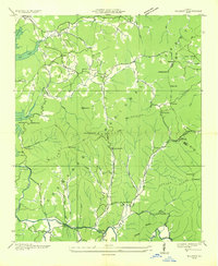
 1935 Lake Toccoa1935 Print · USGSNorth Georgia’s mountain and river life is preserved here during the mid-1930s transition into the hydroelectric era. Researchers can trace family roots through the numerous rural schools and churches, such as Stanley Creek Sch, Union Ch, and landmarks like Stanley Mill.
 - 1935 Map of Wilscot
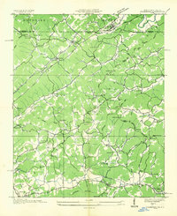
 1935 Wilscot1935 Print · USGSNorth Georgia mountain life is caught in a moment of transition in the mid-1930s as the TVA and CCC arrived in the Blue Ridge. Genealogists can trace old homesteads and landmarks like Star Creek Mill, Sugar Hill Ch, and CCC Camp F 8 along the Toccoa River.
 - 1935 Map of Culberson
 1935 Culberson1935 Print · USGSThe borderlands of North Carolina and Georgia come alive in this mid-1930s study of the mountain gaps and rail corridors. Genealogists and historians can trace family-named sites like Hawkins Mill, Bell Sch, and New Liberty Ch along the winding Hemptown Creek.
 - 1941 Map of Mineral Bluff, 1956 Print
 1941 Mineral Bluff1956 Print · USGSThe tri-state borderlands of Georgia, Tennessee, and North Carolina come alive in the early 1940s as the river-and-rail economy hums near Mineral Bluff. Genealogists and researchers can locate the Galloway Cem, trace the Louisville and Nashville Railroad, and find the CCC Camp 3467 TVA 29 site.4 unique versions available
 - 1941 Map of Culberson, 1958 Print
 1941 Culberson1958 Print · USGSThe borderlands of Georgia and North Carolina are captured here in the early 1940s, showing a landscape defined by mountain ridges and valley mills. Researchers can trace the Louisville and Nashville rail line through Culberson or locate family landmarks like Paris Cem and Loving Sch.4 unique versions available
 - 1942 Map of Culberson
 1942 Culberson1942 Print · USGSThe Georgia and North Carolina borderlands come alive in the early 1940s, revealing a landscape of mountain ridges and family-run mills. Genealogists can trace rural roots at Paris Cem or locate the numerous schoolhouses and churches like Hemp Sch and Zion Hill Ch.2 unique versions available
 - 1943 Map of Mineral Bluff
 1943 Mineral Bluff1943 Print · USGSFannin County and the tri-state border region are shown here in the early 1940s, just after the completion of the Blue Ridge Dam. Researchers can trace family history through sites like Galloway Cem or follow the Louisville and Nashville tracks through Mineral Bluff.
 - 1946 Map of Wilscot, 1956 Print
 1946 Wilscot1956 Print · USGSThe North Georgia mountains of Fannin and Union counties come alive in the mid-forties, showing the rugged backcountry near the Toccoa River. Genealogists can trace family footprints at Wilscot Cem, Tilley Cem, or the remote community at Margret.4 unique versions available
 - 1946 Map of Blue Ridge, 1960 Print
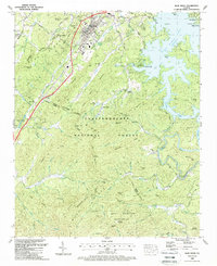
 1946 Blue Ridge1960 Print · USGSFannin and Gilmer Counties are captured here shortly after the war, showing the mountain communities of the Chattahoochee National Forest before modern expansion. Researchers can trace the roots of local families through the many rural landmarks like Cherrylog Church, Ballew Mill, and Snake Nation School.3 unique versions available
 - 1947 Map of Lake Toccoa
 1947 Lake Toccoa1947 Print · USGSFannin and Gilmer counties are captured here shortly after the war, showing the mountain communities and logging routes of North Georgia. Researchers can trace family sites like Antioch Cemetery, find old industrial locations including Greens Mill, or locate the historic Shallowford Bridge.2 unique versions available
 - 1947 Map of Wilscot
 1947 Wilscot1947 Print · USGSThe North Georgia mountains around the Fannin and Union county line appear here in the mid-1940s, showing a landscape of small settlements and mountain gaps. Genealogists can locate family landmarks like Wilscot Cem, Hurst, and the Brawley Mtn Lookout Tower.2 unique versions available
 - 1955 Map of Rome
 1955 Rome1955 Print · USGSThe tri-state borderlands of Georgia, Alabama, and Tennessee appear in the mid-fifties as a landscape of ridge-and-valley industry and river navigation. Genealogists can trace family footprints near Chattanooga, the iron works of Gadsden, and textile towns like Trion or Summerville.
 - 1958 Map of Rome, 1966 Print
 1958 Rome1966 Print · USGSNorthwest Georgia and neighboring Tennessee and Alabama are captured here in the late fifties, showcasing a landscape of high ridges and river valleys. Researchers can trace historic rail lines like the Seaboard Air Line RR and explore the bounds of Cloudland Canyon State Park or Fort Oglethorpe.3 unique versions available
 - 1961 Map of Rome
 1961 Rome1961 Print · USGSNorthwest Georgia and neighboring Tennessee and Alabama are shown here at a moment of significant mid-century growth. Researchers can trace the rail networks of the Central of Georgia or locate landmarks within Chickamauga and Chattanooga Nat Military Park.
 - 1963 Map of Rome
 1963 Rome1963 Print · USGSThe tri-state corner of Georgia, Alabama, and Tennessee is captured here during a period of massive reservoir expansion and post-war growth. Genealogists and historians can trace the rail corridors of the Southern Ry or locate landmarks like Fort Oglethorpe and Cloudland Canyon State Park.
 - 1981 Map of Dalton, 1982 Print
 1981 Dalton1982 Print · USGSNorth Georgia and the tristate borderlands are captured in the early eighties as the textile economy of Dalton thrived alongside the expanding Chattahoochee National Forest. Genealogists and hikers can trace the Appalachian Trail through the high country or locate family-named landmarks like Haskins Mill and Carters Mill.
 - 1988 Map of Wilscot
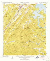
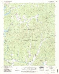 1988 Wilscot1988 Print · USGSFannin County mountain life in the late eighties is recorded here as the forest reclaimed earlier homesteads and mills. Genealogists and local historians can trace family roots at the Skeenah Creek Mill, Van Zandt Cem, and Morganton PO.3 unique versions available
 - 1988 Map of Blue Ridge
 1988 Blue Ridge1988 Print · USGSBlue Ridge and the surrounding North Georgia mountains are documented here in the late eighties, just before modern development expanded. Genealogists and historians can trace family locations through Chastain Mem Park Cem, Cherry Log, and small rural churches like Union Hill Ch.2 unique versions available
 - 1988 Map of Mineral Bluff
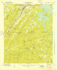
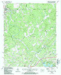 1988 Mineral Bluff1988 Print · USGSThe tri-state border country of Georgia, Tennessee, and North Carolina is captured here in the late eighties, centered on the river-and-rail corridor. Genealogists can trace family connections at Hothouse Cem, Pantertown, and the New River Ch.
 - 1988 Map of Culberson
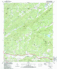 1988 Culberson1988 Print · USGSThe North Carolina and Georgia state line divides this mountain landscape in the late eighties, featuring the communities of Culberson and Morganton. Genealogists can trace family names through landmarks like Mt Herman Ch, Jerusalem Cem, and New Liberty Ch.
Showing maps 1-25 of 46
Top cities near Morganton
- Murphy historical maps
- McCaysville historical maps
- Blue Ridge historical maps
- East Ellijay historical maps
- Copperhill historical maps
- Ducktown historical maps
Frequently asked questions
- What are the different types of historical maps available for Morganton?
- What is the oldest map of Morganton?
- Where can I purchase historical maps of Morganton for my home or office?
- Where can I download high-res historical maps of Morganton?
- Are there historical topographic maps available for Morganton?
- Is there historical aerial imagery available for Morganton?
- Where are historical maps of Morganton sourced from?