1940s Maps of Cherry Log, Georgia
Explore 2 historic maps of Cherry Log from the 1940s. These maps offer a rare glimpse into what life looked like during the 1940s — showing old roads, neighborhoods, homes, and landmarks that have changed or disappeared over time.
Whether you're researching your family's past, planning a metal detecting trip, or studying how Cherry Log's landscape evolved across the 1940s, these high-resolution maps are a powerful tool for exploring the history of this region.
- Focus on a specific era: All maps on this page are from the 1940s, giving you a focused view of this time period.
- See what’s changed: Compare century-old streets, trails, and buildings to today's modern landscape using overlays and satellite layers.
- Research with precision: Use these maps for genealogy, historical research, land use analysis, or educational projects.
- View, download, or print: Maps are fully viewable online in high resolution, and can be downloaded or printed for your own records.
Start exploring Cherry Log's history through authentic maps from the 1940s. This is your window into the past.
Cherry Log, GA maps
(2)- 1946 Map of Cashes Valley, 1956 Print
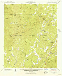 1946 Cashes Valley1956 Print · USGSGilmer and Fannin counties are shown here just after the war, when mountain life followed the ridges and creek beds. Genealogists can trace family names at Johnson Cem, visit Higdon Mill, or follow the Louisville and Nashville tracks through Cherrylog.3 unique versions available
 - 1947 Map of Cashes Valley, 1948 Print
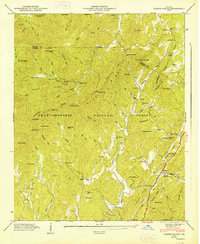 1947 Cashes Valley1948 Print · USGSNorth Georgia mountain life is preserved here just after the war, showing a network of remote hollows and high ridges. Researchers can trace family history through the Johnson Cem, find old schoolhouses like Macedonia Sch, or follow the Tennessee and North Carolina Railroad.2 unique versions available
End of results
Showing maps 1-2 of 2
Top cities near Cherry Log
- Ellijay historical maps
- McCaysville historical maps
- Blue Ridge historical maps
- East Ellijay historical maps
- Copperhill historical maps
- Morganton historical maps
Frequently asked questions
- What are the different types of historical maps available for Cherry Log?
- What is the oldest map of Cherry Log?
- Where can I purchase historical maps of Cherry Log for my home or office?
- Where can I download high-res historical maps of Cherry Log?
- Are there historical topographic maps available for Cherry Log?
- Is there historical aerial imagery available for Cherry Log?
- Where are historical maps of Cherry Log sourced from?