1910s Maps of Glynn County, Georgia
Explore 6 historic maps of Glynn County from the 1910s. These maps offer a rare glimpse into what life looked like during the 1910s — showing old roads, neighborhoods, homes, and landmarks that have changed or disappeared over time.
Whether you're researching your family's past, planning a metal detecting trip, or studying how Glynn County's landscape evolved across the 1910s, these high-resolution maps are a powerful tool for exploring the history of this region.
- Focus on a specific era: All maps on this page are from the 1910s, giving you a focused view of this time period.
- See what’s changed: Compare century-old streets, trails, and buildings to today's modern landscape using overlays and satellite layers.
- Research with precision: Use these maps for genealogy, historical research, land use analysis, or educational projects.
- View, download, or print: Maps are fully viewable online in high resolution, and can be downloaded or printed for your own records.
Start exploring Glynn County's history through authentic maps from the 1910s. This is your window into the past.
Glynn County, GA maps
(6)- 1917 Map of Nahunta, 1958 Print
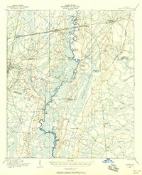 1917 Nahunta1958 Print · USGSSoutheast Georgia's riverine and rail networks are preserved here during the early twentieth century. Researchers can trace the legacy of rural education and transport through Ammons Ferry Bridge, the Jacksonville Post Road, and community anchors like Bixley Chapel.2 unique versions available
 - 1918 Map of Cumberland Island
 1918 Cumberland Island1918 Print · USGSCoastal Georgia at the end of the Great War was a world of secluded island estates and vital maritime waterways. Researchers can trace the early infrastructure of the barrier islands through labels like Greyfield, the Lighthouse (Abandoned), and Plum Orchard Wharf.
 - 1918 Map of Hortense
 1918 Hortense1918 Print · USGSSoutheast Georgia during the Great War era reveals a landscape shaped by river systems and steam-age railroads. Genealogists can trace family roots through numerous rural landmarks like Pendarvis School, Mt Zion Church, and the river crossing at Rosin Landing.2 unique versions available
 - 1918 Map of Everett City
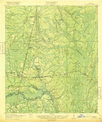
 1918 Everett City1918 Print · USGSCoastal Georgia at the end of the Great War was a world of vast river swamps and emerging rail junctions. Genealogists and historians can trace family locations through isolated landmarks like Bull Island School, the Ft Barrington Ferry, and the timber-driven siding at Thalmann.2 unique versions available
 - 1918 Map of Nahunta
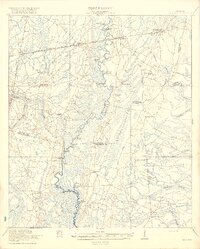 1918 Nahunta1918 Print · USGSSoutheastern Georgia at the end of the Great War reveals a landscape defined by the winding Satilla River and its vast swamps. Researchers can locate early schools and river crossings like Ammons Ferry Bridge, Oak Grove School, and Bixley Chapel.2 unique versions available
 - 1918 Map of Bladen
 1918 Bladen1918 Print · USGSThe Georgia coast at the end of the Great War reveals a landscape of tidal marshes and vital rail junctions. Genealogists can trace family roots through sites like Brockington School, Dover Bluff, and the junction at Bladen.2 unique versions available
End of results
Showing maps 1-6 of 6
Top cities of Glynn County
- Brunswick historical maps
- Saint Simons historical maps
- Country Club Estates historical maps
- Dock Junction historical maps
Frequently asked questions
- What are the different types of historical maps available for Glynn County?
- What is the oldest map of Glynn County?
- Where can I purchase historical maps of Glynn County for my home or office?
- Where can I download high-res historical maps of Glynn County?
- Are there historical topographic maps available for Glynn County?
- Is there historical aerial imagery available for Glynn County?
- Where are historical maps of Glynn County sourced from?