1950s Maps of Glynn County, Georgia
Explore 12 historic maps of Glynn County from the 1950s. These maps offer a rare glimpse into what life looked like during the 1950s — showing old roads, neighborhoods, homes, and landmarks that have changed or disappeared over time.
Whether you're researching your family's past, planning a metal detecting trip, or studying how Glynn County's landscape evolved across the 1950s, these high-resolution maps are a powerful tool for exploring the history of this region.
- Focus on a specific era: All maps on this page are from the 1950s, giving you a focused view of this time period.
- See what’s changed: Compare century-old streets, trails, and buildings to today's modern landscape using overlays and satellite layers.
- Research with precision: Use these maps for genealogy, historical research, land use analysis, or educational projects.
- View, download, or print: Maps are fully viewable online in high resolution, and can be downloaded or printed for your own records.
Start exploring Glynn County's history through authentic maps from the 1950s. This is your window into the past.
Glynn County, GA maps
(12)- 1954 Map of Altamaha Sound, 1959 Print
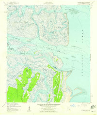 1954 Altamaha Sound1959 Print · USGSThe Georgia coast at the edge of the Atlantic was a labyrinth of tidal marshes and remote island outposts in the mid-1950s. Genealogists and coastal historians can trace early landmarks like Butler Point, the winding Intracoastal Waterway, and the pristine stretches of the Wolf Island National Wildlife Refuge.2 unique versions available
 - 1955 Map of Sea Island, 1959 Print
 1955 Sea Island1959 Print · USGSCoastal Georgia's barrier islands appear here in the mid-fifties, balancing secluded marshlands with growing vacation settlements. Trace the roots of local communities like German Village and Harrington, or locate the U.S. Coast Guard Station and historic Artesian Wells.
 - 1956 Map of Bladen, 1959 Print
 1956 Bladen1959 Print · USGSCoastal Glynn and Camden counties are captured here in the mid-1950s, a period defined by the intersections of the Atlantic Coast Line and the Seaboard Air Line. Researchers can locate family landmarks such as Higgenbottom Cem and rural centers like Brookman and New Zion Ch.
 - 1956 Map of Brunswick East, 1959 Print
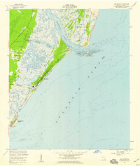
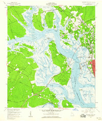
 1956 Brunswick East1959 Print · USGSCoastal Georgia in the mid-fifties is defined by its deep-water channels, naval aviation, and the growing connection between the mainland and the Golden Isles. Researchers can trace the layout of Jewtown, the grounds of Fort Frederica National Monument, and historic schools like Risley High Sch.2 unique versions available
 - 1956 Map of Darien, 1959 Print
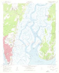
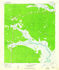
 1956 Darien1959 Print · USGSCoastal Georgia's river delta and the historic port of Darien are captured here in the mid-fifties, showing a landscape defined by tidewater islands and colonial ruins. Genealogists and historians can trace the Brunswick-Altamaha Canal, family burial grounds like Butler Cem, and the Santo Domingo Mission Ruins.2 unique versions available
 - 1956 Map of Brunswick West, 1960 Print
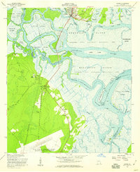
 1956 Brunswick West1960 Print · USGSThe coastal marshlands and river junctions of Glynn County are captured here in the mid-1950s. Genealogists and historians can trace rail lines to Southern Junction, locate the Blythe Island Naval Reservation, and find rural landmarks like Emanuel Ch.2 unique versions available
 - 1956 Map of Brunswick, 1968 Print
 1956 Brunswick1968 Print · USGSThe Georgia coast in the mid-twentieth century is a wild expanse of barrier islands and massive river deltas. You can trace the development of the maritime economy and military presence at Brunswick, or locate historic sites like Fort Frederica National Monument and Harris Neck National Wildlife Refuge.2 unique versions available
 - 1957 Map of Jekyll Island, 1959 Print
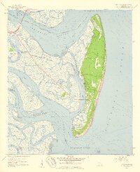 1957 Jekyll Island1959 Print · USGSJekyll Island in the late fifties is captured here as a state-protected landscape of maritime forests and tidal marshes. Genealogists and historians can trace family-named roads like Maurice Road and Captain Wylly Road or locate Faith Chapel.2 unique versions available
 - 1957 Map of Jacksonville, 1967 Print
 1957 Jacksonville1967 Print · USGSCoastal Florida and Georgia meet in the late fifties, showcasing a landscape of naval aviation, deep-water terminals, and barrier island communities. Researchers can trace the mid-century footprints of NAS Jacksonville, find small communities like Franklintown, and locate the historic Fort Clinch State Park.3 unique versions available
 - 1958 Map of Cumberland Island North, 1959 Print
 1958 Cumberland Island North1959 Print · USGSCoastal Georgia's barrier islands appear in detail during the late fifties, showcasing the intricate tidal reaches of Camden County. Researchers can trace historic sites like Cumberland Wharf, the Little Cumberland Island Lighthouse, and early Cems near Halfmoon Bluff.
 - 1959 Map of Jacksonville
 1959 Jacksonville1959 Print · USGSNortheast Florida and Southeast Georgia are seen here in the late fifties, dominated by the maritime activity of the St Johns River and the Atlantic coast. Researchers can trace the mid-century layout of Jacksonville and identify sprawling military sites like Camp Blanding Military Reservation and Kings Bay Ammunition Terminal.
 - 1959 Map of Waverly, 1960 Print
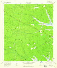
 1959 Waverly1960 Print · USGSCamden County's coastal lowlands are mapped here in the late fifties, showcasing the vital corridor where the Ocean Highway met the Little Satilla River. Genealogists and historians can locate family landmarks like Horse Stamp Ch, Quarterman Cem, and the riverfront at Spring Bluff.
End of results
Showing maps 1-12 of 12
Top cities of Glynn County
- Brunswick historical maps
- Saint Simons historical maps
- Country Club Estates historical maps
- Dock Junction historical maps
Frequently asked questions
- What are the different types of historical maps available for Glynn County?
- What is the oldest map of Glynn County?
- Where can I purchase historical maps of Glynn County for my home or office?
- Where can I download high-res historical maps of Glynn County?
- Are there historical topographic maps available for Glynn County?
- Is there historical aerial imagery available for Glynn County?
- Where are historical maps of Glynn County sourced from?