1950s Maps of Brunswick, Georgia
Explore 4 historic maps of Brunswick from the 1950s. These maps offer a rare glimpse into what life looked like during the 1950s — showing old roads, neighborhoods, homes, and landmarks that have changed or disappeared over time.
Whether you're researching your family's past, planning a metal detecting trip, or studying how Brunswick's landscape evolved across the 1950s, these high-resolution maps are a powerful tool for exploring the history of this region.
- Focus on a specific era: All maps on this page are from the 1950s, giving you a focused view of this time period.
- See what’s changed: Compare century-old streets, trails, and buildings to today's modern landscape using overlays and satellite layers.
- Research with precision: Use these maps for genealogy, historical research, land use analysis, or educational projects.
- View, download, or print: Maps are fully viewable online in high resolution, and can be downloaded or printed for your own records.
Start exploring Brunswick's history through authentic maps from the 1950s. This is your window into the past.
Brunswick, GA maps
(4)- 1956 Map of Brunswick East, 1959 Print
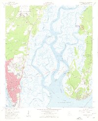 1956 Brunswick East1959 Print · USGSCoastal Georgia in the mid-fifties is defined by its deep-water channels, naval aviation, and the growing connection between the mainland and the Golden Isles. Researchers can trace the layout of Jewtown, the grounds of Fort Frederica National Monument, and historic schools like Risley High Sch.2 unique versions available
 - 1956 Map of Brunswick West, 1960 Print
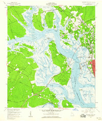 1956 Brunswick West1960 Print · USGSThe coastal marshlands and river junctions of Glynn County are captured here in the mid-1950s. Genealogists and historians can trace rail lines to Southern Junction, locate the Blythe Island Naval Reservation, and find rural landmarks like Emanuel Ch.2 unique versions available
 - 1956 Map of Brunswick, 1968 Print
 1956 Brunswick1968 Print · USGSThe Georgia coast in the mid-twentieth century is a wild expanse of barrier islands and massive river deltas. You can trace the development of the maritime economy and military presence at Brunswick, or locate historic sites like Fort Frederica National Monument and Harris Neck National Wildlife Refuge.2 unique versions available
 - 1957 Map of Jekyll Island, 1959 Print
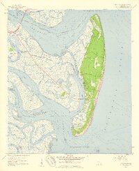 1957 Jekyll Island1959 Print · USGSJekyll Island in the late fifties is captured here as a state-protected landscape of maritime forests and tidal marshes. Genealogists and historians can trace family-named roads like Maurice Road and Captain Wylly Road or locate Faith Chapel.2 unique versions available
End of results
Showing maps 1-4 of 4
Top cities near Brunswick
- Saint Simons historical maps
- Country Club Estates historical maps
- Dock Junction historical maps
- Darien historical maps
- Woodbine historical maps
Top neighborhoods of Brunswick
- Magnolia Park historical maps
- McIntyre Court historical maps
- Glynnvilla historical maps
- Gordon Oaks Homes historical maps
- Suburban Estates historical maps
- College Park historical maps
See more
Frequently asked questions
- What are the different types of historical maps available for Brunswick?
- What is the oldest map of Brunswick?
- Where can I purchase historical maps of Brunswick for my home or office?
- Where can I download high-res historical maps of Brunswick?
- Are there historical topographic maps available for Brunswick?
- Is there historical aerial imagery available for Brunswick?
- Where are historical maps of Brunswick sourced from?