1970s Maps of Brunswick, Georgia
Explore 5 historic maps of Brunswick from the 1970s. These maps offer a rare glimpse into what life looked like during the 1970s — showing old roads, neighborhoods, homes, and landmarks that have changed or disappeared over time.
Whether you're researching your family's past, planning a metal detecting trip, or studying how Brunswick's landscape evolved across the 1970s, these high-resolution maps are a powerful tool for exploring the history of this region.
- Focus on a specific era: All maps on this page are from the 1970s, giving you a focused view of this time period.
- See what’s changed: Compare century-old streets, trails, and buildings to today's modern landscape using overlays and satellite layers.
- Research with precision: Use these maps for genealogy, historical research, land use analysis, or educational projects.
- View, download, or print: Maps are fully viewable online in high resolution, and can be downloaded or printed for your own records.
Start exploring Brunswick's history through authentic maps from the 1970s. This is your window into the past.
Brunswick, GA maps
(5)- 1978 Map of Brunswick
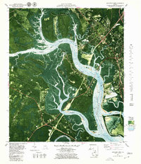
 1978 Brunswick1978 Print · USGSThe Georgia coast and its barrier islands are captured in the late 1970s, as I-95 and the rail lines shaped the growth of coastal towns. Genealogists and historians can trace family locations across the islands or locate sites near Fort Stewart, Darien, and Ludowici.2 unique versions available
 - 1979 Map of Jekyll Island, 1980 Print
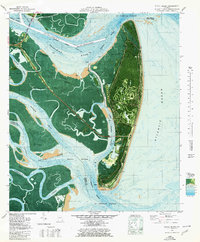 1979 Jekyll Island1980 Print · USGSJekyll Island at the close of the seventies reveals a coastal landscape transitioning from its historic roots to a modern state park. Trace family history or local landmarks like the Ruins of Georgias First Brewery, the Jekyll Island Airport, and Cedar Hammock.
 - 1979 Map of Brunswick West, 1980 Print
 1979 Brunswick West1980 Print · USGSCoastal Glynn County in the late seventies is defined by the heavy industry of the Brunswick waterfront and the winding tidal creeks of the western marshes. Genealogists and researchers can trace local congregations like Galilee Ch or follow the rails from Southern Junction across the Seaboard Coast Line.2 unique versions available
 - 1979 Map of Brunswick East, 1980 Print
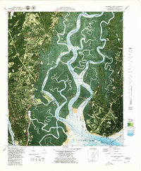 1979 Brunswick East1980 Print · USGSThe Georgia coast near St. Simons Island comes to life in this late-seventies survey of tidal rivers and growing settlements. Researchers can trace the layout of Harrington, locate the Stranger Cem, and identify landmarks like the St Simons Lighthouse.3 unique versions available
 - 1979 Map of Dover Bluff, 1980 Print
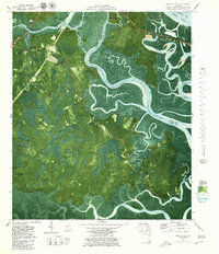 1979 Dover Bluff1980 Print · USGSThe Georgia coast near Dover Bluff comes into focus in the late 1970s, showing the intricate tidal marshlands of COLONELS ISLAND. Researchers can pinpoint the Old Spanish Mission Ruins and trace family roots through sites like Hull Cem and Ella Park Ch.2 unique versions available
End of results
Showing maps 1-5 of 5
Top cities near Brunswick
- Saint Simons historical maps
- Country Club Estates historical maps
- Dock Junction historical maps
- Darien historical maps
- Woodbine historical maps
Top neighborhoods of Brunswick
- Magnolia Park historical maps
- McIntyre Court historical maps
- Glynnvilla historical maps
- Gordon Oaks Homes historical maps
- Suburban Estates historical maps
- College Park historical maps
See more
Frequently asked questions
- What are the different types of historical maps available for Brunswick?
- What is the oldest map of Brunswick?
- Where can I purchase historical maps of Brunswick for my home or office?
- Where can I download high-res historical maps of Brunswick?
- Are there historical topographic maps available for Brunswick?
- Is there historical aerial imagery available for Brunswick?
- Where are historical maps of Brunswick sourced from?