1970s Maps of Grady County, Georgia
Explore 13 historic maps of Grady County from the 1970s. These maps offer a rare glimpse into what life looked like during the 1970s — showing old roads, neighborhoods, homes, and landmarks that have changed or disappeared over time.
Whether you're researching your family's past, planning a metal detecting trip, or studying how Grady County's landscape evolved across the 1970s, these high-resolution maps are a powerful tool for exploring the history of this region.
- Focus on a specific era: All maps on this page are from the 1970s, giving you a focused view of this time period.
- See what’s changed: Compare century-old streets, trails, and buildings to today's modern landscape using overlays and satellite layers.
- Research with precision: Use these maps for genealogy, historical research, land use analysis, or educational projects.
- View, download, or print: Maps are fully viewable online in high resolution, and can be downloaded or printed for your own records.
Start exploring Grady County's history through authentic maps from the 1970s. This is your window into the past.
Grady County, GA maps
(13)- 1971 Map of Meigs, 1972 Print
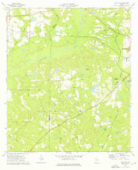
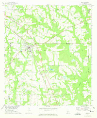 1971 Meigs1972 Print · USGSMeigs and the surrounding Georgia countryside are mapped here in the early seventies, capturing the intersection of four counties. Genealogists can trace family landmarks like Sunset Cem, Ravenwood Sch, and the quiet community of Quality along the Seaboard Coast Line.
 - 1971 Map of Gee Pond, 1974 Print
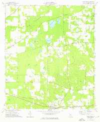
 1971 Gee Pond1974 Print · USGSThe rural borderlands of Mitchell and Grady Counties in the early seventies are a patchwork of small churches and natural sinkholes. Genealogists can trace family connections at Union Cem or Maxwell Cem and locate landmarks like the Hawthorne Trail Lookout Tower.2 unique versions available
 - 1971 Map of Vada, 1974 Print
 1971 Vada1974 Print · USGSDecatur and Mitchell counties are captured here in the early seventies, showing a rural landscape defined by karst sinks and small farming communities. Researchers can trace family sites at Salem Cem, Vada, and numerous country churches like Oak Grove Ch.2 unique versions available
 - 1971 Map of Pelham, 1974 Print
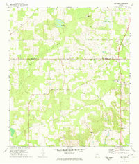
 1971 Pelham1974 Print · USGSThe outskirts of Pelham and the rural border of Mitchell and Grady Counties are captured here in the early 1970s. Local researchers can trace family sites among numerous landmarks including Macedonia Ch, St James Cem, and the Shiver Sch campus.2 unique versions available
 - 1974 Map of Pine Park, 1976 Print
 1974 Pine Park1976 Print · USGSSouth Georgia during the mid-seventies reveals a landscape of river-fed bottomlands and rural rail stops. You can trace family roots through numerous country churches like Ireland Ch and Upchurch Ch or locate family plots at Sunkola Cem and Pierce Chapel Cem.
 - 1974 Map of Whigham, 1976 Print
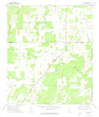
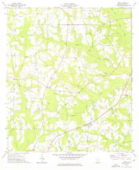
 1974 Whigham1976 Print · USGSIn the mid-1970s, the rural Grady County landscape centered on the railway town of Whigham and its timber-lined creeks. Genealogists can trace family roots through numerous sites like Woodlawn Cem, Peoples Still, and Union Spring Ch.
 - 1974 Map of Climax North, 1976 Print
 1974 Climax North1976 Print · USGSThe rural landscape of Decatur County in the mid-1970s reveals a community centered on the rail junction at Climax. Genealogists and local historians can trace rural family roots through numerous sites like Fleatown Cem, Travelers Rest Ch, and Parker Courthouse.
 - 1974 Map of Reno, 1976 Print
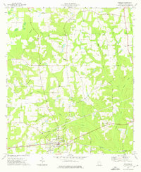
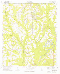
 1974 Reno1976 Print · USGSGrady County rural life in the mid-seventies is defined by its quiet settlements and an extensive network of country churches. Researchers can trace family ties through Nickleville, Butler Cem, and the many local congregations like St Lukes Ch.
 - 1974 Map of Cairo North, 1976 Print
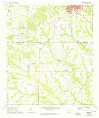
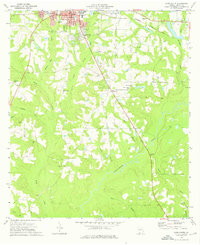
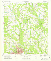 1974 Cairo North1976 Print · USGSThe city of Cairo and its surrounding rural townships are shown in the mid-seventies just as the local infrastructure was modernizing. Researchers can trace family sites at Greenwood Cemetery or locate landmarks like the County Prison Farm and Tired Creek Ch.
 - 1974 Map of Ochlocknee, 1976 Print
 1974 Ochlocknee1976 Print · USGSIn the mid-1970s, the rural corridor between Grady and Thomas County centered on the rail-aligned community of Ochlocknee. Researchers can trace the placement of local landmarks like the Childrens Center Sch, Dawes Chapel, and family-named sites such as Hendry Cem.
 - 1974 Map of Cairo South, 1976 Print
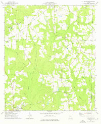
 1974 Cairo South1976 Print · USGSSouth of Cairo in the mid-1970s, the landscape is a patchwork of family-named creeks and rural parish life. Genealogists can trace decades of history through landmarks like Myrtle Hill Cem, Shiloh Ch, and the winding banks of the Ochlockonee River.
 - 1974 Map of Climax South, 1976 Print
 1974 Climax South1976 Print · USGSDecatur County during the mid-seventies shows a landscape of established rural settlements and rail-line communities. Researchers can trace family history through numerous rural landmarks like Samuel Cem, Antioch Ch, and the town of Attapulgus.
 - 1978 Map of Bainbridge, 1980 Print
 1978 Bainbridge1980 Print · USGSIn the late seventies, this Georgia-Florida borderland was defined by the confluence of the Flint and Chattahoochee rivers. Trace the region's infrastructure via the Seaboard Coast Line Railroad and find sites like Bainbridge State Hospital.
End of results
Showing maps 1-13 of 13
Top cities of Grady County
Frequently asked questions
- What are the different types of historical maps available for Grady County?
- What is the oldest map of Grady County?
- Where can I purchase historical maps of Grady County for my home or office?
- Where can I download high-res historical maps of Grady County?
- Are there historical topographic maps available for Grady County?
- Is there historical aerial imagery available for Grady County?
- Where are historical maps of Grady County sourced from?