1970s Maps of Cairo, Georgia
Explore 3 historic maps of Cairo from the 1970s. These maps offer a rare glimpse into what life looked like during the 1970s — showing old roads, neighborhoods, homes, and landmarks that have changed or disappeared over time.
Whether you're researching your family's past, planning a metal detecting trip, or studying how Cairo's landscape evolved across the 1970s, these high-resolution maps are a powerful tool for exploring the history of this region.
- Focus on a specific era: All maps on this page are from the 1970s, giving you a focused view of this time period.
- See what’s changed: Compare century-old streets, trails, and buildings to today's modern landscape using overlays and satellite layers.
- Research with precision: Use these maps for genealogy, historical research, land use analysis, or educational projects.
- View, download, or print: Maps are fully viewable online in high resolution, and can be downloaded or printed for your own records.
Start exploring Cairo's history through authentic maps from the 1970s. This is your window into the past.
Cairo, GA maps
(3)- 1974 Map of Cairo North, 1976 Print
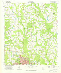 1974 Cairo North1976 Print · USGSThe city of Cairo and its surrounding rural townships are shown in the mid-seventies just as the local infrastructure was modernizing. Researchers can trace family sites at Greenwood Cemetery or locate landmarks like the County Prison Farm and Tired Creek Ch.
 - 1974 Map of Cairo South, 1976 Print
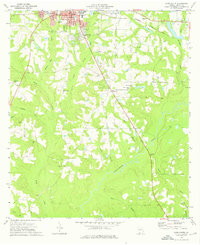 1974 Cairo South1976 Print · USGSSouth of Cairo in the mid-1970s, the landscape is a patchwork of family-named creeks and rural parish life. Genealogists can trace decades of history through landmarks like Myrtle Hill Cem, Shiloh Ch, and the winding banks of the Ochlockonee River.
 - 1978 Map of Bainbridge, 1980 Print
 1978 Bainbridge1980 Print · USGSIn the late seventies, this Georgia-Florida borderland was defined by the confluence of the Flint and Chattahoochee rivers. Trace the region's infrastructure via the Seaboard Coast Line Railroad and find sites like Bainbridge State Hospital.
End of results
Showing maps 1-3 of 3
Top cities near Cairo
- Thomasville historical maps
- Havana historical maps
- Meigs historical maps
- Ochlocknee historical maps
- Whigham historical maps
- Climax historical maps
Top neighborhoods of Cairo
Frequently asked questions
- What are the different types of historical maps available for Cairo?
- What is the oldest map of Cairo?
- Where can I purchase historical maps of Cairo for my home or office?
- Where can I download high-res historical maps of Cairo?
- Are there historical topographic maps available for Cairo?
- Is there historical aerial imagery available for Cairo?
- Where are historical maps of Cairo sourced from?