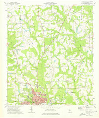
1974 Map of Cairo North
USGS Topo · Published 1976About this map
Cairo serves as the focal point of this South Georgia landscape, where a dense grid of numbered avenues such as 4th Ave NW and 12th Ave NE gives way to a network of creeks and rural outposts. The southern edge of the survey is defined by the Seaboard Coast Line railroad and local institutions like the County Prison Farm and the Greenwood Cemetery. Beyond the town limits, the geography is shaped by the numerous branches of Tired Creek and Barnetts Creek, which carve through the terrain toward smaller settlements like Akridge and Capel. Several country churches, including Pine Level Ch and New Zion Ch, anchor the rural communities, while the Cairo-Grady County Airport and Radio Tower (WGRA) represent the infrastructure of the mid-1970s.
Find a feature on this map
57 named features on this map. Tap any name to fly to it.
Don’t see what you’re looking for? This feature index may not catch every label — zoom into the map to look around manually.
Map Details
Editions of this 1974 Cairo North Map
This is the sole edition of this map. No revisions or reprints were ever made.
Other maps of this area

1953 · Dothan
USGS Topo · 1:250,000

1954 · Dothan
USGS Topo · 1:250,000

1954 · Tallahassee
USGS Topo · 1:250,000

1955 · Dothan
USGS Topo · 1:250,000

1955 · Whigham
USGS Topo · 1:62,500

1956 · Cairo
USGS Topo · 1:62,500

1959 · Tallahassee
USGS Topo · 1:250,000

1960 · Tallahassee
USGS Topo · 1:250,000

1971 · Meigs
USGS Topo · 1:24,000

1971 · Gee Pond
USGS Topo · 1:24,000