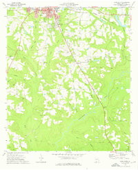
1974 Map of Cairo South
USGS Topo · Published 1976About this map
Cairo and its southern suburbs like Gordon Heights are defined by a network of dendritic creek systems feeding into the Ochlockonee River. The landscape in the mid-1970s reflects a rural community rooted in localized institutional life, with a high density of country churches and family cemeteries such as Rawls Cem and Poplar Spring Cem. The northern portion of the map captures the transition from the city's grid to the winding paths of Parkers Mill Creek and Tired Creek.
Find a feature on this map
38 named features on this map. Tap any name to fly to it.
Don’t see what you’re looking for? This feature index may not catch every label — zoom into the map to look around manually.
Map Details
Editions of this 1974 Cairo South Map
This is the sole edition of this map. No revisions or reprints were ever made.
Other maps of this area

1954 · Tallahassee
USGS Topo · 1:250,000

1955 · Whigham
USGS Topo · 1:62,500

1956 · Cairo
USGS Topo · 1:62,500

1956 · Calvary
USGS Topo · 1:24,000

1957 · Beachton
USGS Topo · 1:24,000

1957 · Miccosukee NE
USGS Topo · 1:24,000

1959 · Tallahassee
USGS Topo · 1:250,000

1960 · Tallahassee
USGS Topo · 1:250,000
1974 · Pine Park
USGS Topo · 1:24,000
1974 · Whigham
USGS Topo · 1:24,000