1990s Maps of Duluth, Georgia
Explore 7 historic maps of Duluth from the 1990s. These maps offer a rare glimpse into what life looked like during the 1990s — showing old roads, neighborhoods, homes, and landmarks that have changed or disappeared over time.
Whether you're researching your family's past, planning a metal detecting trip, or studying how Duluth's landscape evolved across the 1990s, these high-resolution maps are a powerful tool for exploring the history of this region.
- Focus on a specific era: All maps on this page are from the 1990s, giving you a focused view of this time period.
- See what’s changed: Compare century-old streets, trails, and buildings to today's modern landscape using overlays and satellite layers.
- Research with precision: Use these maps for genealogy, historical research, land use analysis, or educational projects.
- View, download, or print: Maps are fully viewable online in high resolution, and can be downloaded or printed for your own records.
Start exploring Duluth's history through authentic maps from the 1990s. This is your window into the past.
Duluth, GA maps
(7)- 1992 Map of Norcross
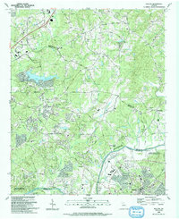
 1992 Norcross1992 Print · USGSGwinnett County’s rapid suburban transformation is on full display in the early nineties as residential neighborhoods spread between the Chattahoochee River and Lilburn. Researchers can trace local genealogy and land use through sites like Peachtree Mem Cem, the Southern rail line, and the massive Quarry near Beaver Ruin Creek.2 unique versions available
 - 1992 Map of Duluth, 1993 Print
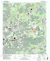
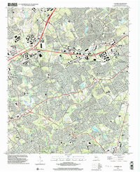
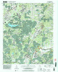
 1992 Duluth1993 Print · USGSGwinnett and Fulton counties were undergoing rapid transformation in the early nineties as suburban growth reached historic hamlets. Local historians can trace the foundations of Ocee and Shake Rag or locate family sites like Rogers Cem and Union Hill Ch.
 - 1992 Map of Suwanee, 1993 Print
 1992 Suwanee1993 Print · USGSGwinnett County's northern corridor comes into focus in the early nineties as suburban development expands near Suwanee and Sugar Hill. Genealogists and local historians can trace legacy sites like Old Peachtree Ch, Sudderth Cem, and the path of the SOUTHERN RAILWAY.
 - 1992 Map of Luxomni, 1993 Print
 1992 Luxomni1993 Print · USGSGwinnett County's rapid suburbanization is documented here in the early nineties, showing how older crossroads communities adapted to new infrastructure. Genealogists and locals can trace family-named sites like McKendree Cem and Pharr School alongside the Seaboard System rail line.
 - 1999 Map of Luxomni, 2003 Print
 1999 Luxomni2003 Print · USGSGwinnett County's suburban landscape emerges at the turn of the millennium as residential growth surrounds established community hubs. Researchers can trace family history through local sites like Ford Cemetery, Luxomni Church, and Pharr School.
 - 1999 Map of Duluth, 2003 Print
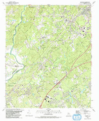
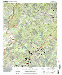
 1999 Duluth2003 Print · USGSNorth Atlanta’s suburban expansion is in full swing at the close of the twentieth century, bridging the space between Gwinnett and Fulton counties. Researchers can trace the evolution of rural communities into modern suburbs through landmarks like Union Hill Ch, Lake Windward, and the Rogers Cem.
 - 1999 Map of Suwanee, 2003 Print
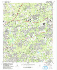
 1999 Suwanee2003 Print · USGSGwinnett County's rapid expansion meets the river at the end of the nineties. Genealogists and historians can trace old family sites and landmarks like Riverside Cem, Old Peachtree Ch, and the crossing at Mc Ginnis Ferry Road.
End of results
Showing maps 1-7 of 7
Top cities near Duluth
- Atlanta historical maps
- Sandy Springs historical maps
- Roswell historical maps
- Johns Creek historical maps
- Alpharetta historical maps
- Brookhaven historical maps
See more
Top neighborhoods of Duluth
- Carriage Gate historical maps
- Chattawood historical maps
- Howell Wood historical maps
- Centurion Hills historical maps
- Forest Manor North historical maps
- GardenDale TownHomes historical maps
See more
Frequently asked questions
- What are the different types of historical maps available for Duluth?
- What is the oldest map of Duluth?
- Where can I purchase historical maps of Duluth for my home or office?
- Where can I download high-res historical maps of Duluth?
- Are there historical topographic maps available for Duluth?
- Is there historical aerial imagery available for Duluth?
- Where are historical maps of Duluth sourced from?